Appraisal
Antique Map Of Maine Et Loire By Victor Levasseur Appraisal
Get AI-powered appraisal estimates for your Antique Map Of Maine Et Loire By Victor Levasseur. Upload a photo for instant valuation.
Recent antique map of maine et loire by victor levasseur appraisals
Antique Maps and Prints
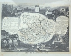
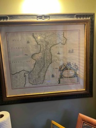
Antique Map of Maine-et-Loire by Victor Levasseur

Antique Cartography and Ephemera
Carte Physique et Minéralogique de la France (1862) by Victor Levasseur

Antique Maps and Cartography
1846 Victor Levasseur 'Carte de l'Inde' Map

Antique Cartography and Art Prints
Victor Levasseur's Cartographic Engraving of the Département de Vaucluse
Antique Cartography and Prints
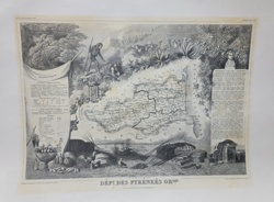
Victor Levasseur Atlas National Illustré: Dépt des Pyrénées Orles

Antique Maps and Prints
Victor Levasseur's Cartographic Engraving of the Departement de la Gironde
Vintage Glassware / Collectible Wine Bottles
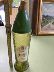
Vintage Muscadet de Sèvre et Maine Fish-Shaped Wine Bottle
Antique Cartography and Historical Prints
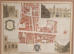
Stow's Survey of London: Cheap Ward Map
Antique Maps and Cartography
Framed Hand-Colored Map of Calabria Citra by Willem Blaeu
Art - Prints and Maps
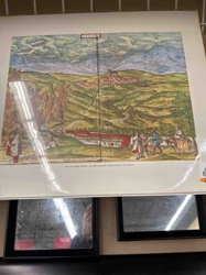
Reproduction Print of Alhama de Granada by Georg Braun and Frans Hogenberg
Antique Maps and Prints
Antique Map of Maine-et-Loire by Victor Levasseur
Antique Cartography and Ephemera
Carte Physique et Minéralogique de la France (1862) by Victor Levasseur
Antique Maps and Cartography
1846 Victor Levasseur 'Carte de l'Inde' Map
Antique Cartography and Art Prints
Victor Levasseur's Cartographic Engraving of the Département de Vaucluse
Antique Cartography and Prints
Victor Levasseur Atlas National Illustré: Dépt des Pyrénées Orles
Antique Maps and Prints
Victor Levasseur's Cartographic Engraving of the Departement de la Gironde
Vintage Glassware / Collectible Wine Bottles
Vintage Muscadet de Sèvre et Maine Fish-Shaped Wine Bottle
Antique Cartography and Historical Prints
Stow's Survey of London: Cheap Ward Map
Antique Maps and Cartography
Framed Hand-Colored Map of Calabria Citra by Willem Blaeu
Art - Prints and Maps
Reproduction Print of Alhama de Granada by Georg Braun and Frans Hogenberg

Antique Maps and Prints
Victor Levasseur Antique Map of the Tarn-et-Garonne Department

Antique Maps and Prints
Victor Levasseur Map of the Département de Vaucluse

Antique Cartography and Prints
Victor Levasseur 'Atlas National Illustré' Map of the Department of Aude, France
Antique Cartography and Fine Art Prints
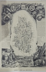
Victor Levasseur Illustrative Map of Dépt. de la Meuse (Atlas National Illustré)
Antique Cartography and Prints
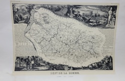
Victor Levasseur's 'Département de la Somme' Map from Atlas National Illustré
Antique Cartography & Prints
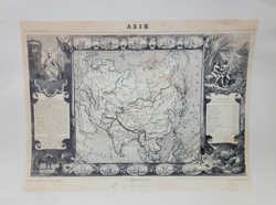
Levasseur Antique Map of Asia (Asie) from the 'Atlas National Illustre'
Antique Cartography and Maps
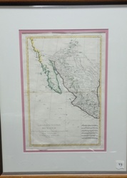
L'Ancien et le Nouveau Mexique (Ancient and New Mexico) Map by Rigobert Bonne

Antique Prints and Map Art
Section of the Thames Embankment, 1867: Hand-Coloured Engraving
Antique Maps and Cartography
Framed 17th Century Map of Calabria Ultra by Willem Blaeu
Antiquarian Maps and Prints
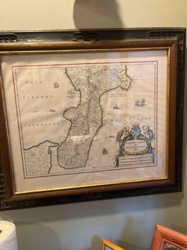
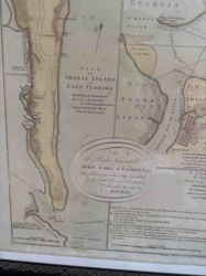
Plan of Amelia Island in East Florida by William Fuller
Antique Maps and Prints
Victor Levasseur Antique Map of the Tarn-et-Garonne Department
Antique Maps and Prints
Victor Levasseur Map of the Département de Vaucluse
Antique Cartography and Prints
Victor Levasseur 'Atlas National Illustré' Map of the Department of Aude, France
Antique Cartography and Fine Art Prints
Victor Levasseur Illustrative Map of Dépt. de la Meuse (Atlas National Illustré)
Antique Cartography and Prints
Victor Levasseur's 'Département de la Somme' Map from Atlas National Illustré
Antique Cartography & Prints
Levasseur Antique Map of Asia (Asie) from the 'Atlas National Illustre'
Antique Cartography and Maps
L'Ancien et le Nouveau Mexique (Ancient and New Mexico) Map by Rigobert Bonne
Antique Prints and Map Art
Section of the Thames Embankment, 1867: Hand-Coloured Engraving
Antique Maps and Cartography
Framed 17th Century Map of Calabria Ultra by Willem Blaeu
Antiquarian Maps and Prints
Plan of Amelia Island in East Florida by William Fuller
Process
How our AI antique map of maine et loire by victor levasseur appraisal works
- 01
Upload your photo
Take a clear photo of your antique map of maine et loire by victor levasseur and upload it. One photo is all you need.
- 02
AI analysis
Our advanced AI technology analyzes your item.
- 03
Receive estimate
Get a detailed appraisal report with estimated value range, market insights, and item details.
Get the best appraisal
For the best results
- Use good lighting to capture all details
- Place item on a neutral background
- Include any identifying marks or labels
- Ensure the entire item is visible in frame
Ready to appraise your antique map of maine et loire by victor levasseur?
Get your free AI-powered appraisal in under 60 seconds
No registration required · Free to use · Instant results