AI Item Analysis
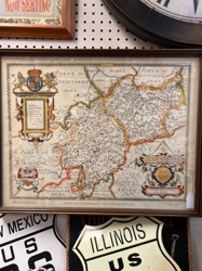
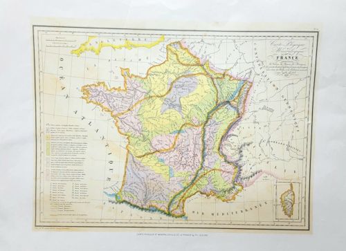
This is an antique steel-engraved map of France titled 'Carte Physique et Minéralogique de la France.' It was originally published in 1862 as part of the 'Atlas National Illustré' by the renowned cartographer Victor Levasseur. The map is printed on medium-weight paper with hand-colored detailing. It features a pastel color palette using shades of yellow, green, pink, and blue to differentiate various geological and mineralogical regions of the country. The central map is surrounded by a detailed legend on the lower-left corner explaining the color-coding for mineral deposits (such as coal, iron, and salt) and mountain ranges. The top right features a decorative cartouche with elegant script lettering. The piece measures approximately 30 x 44 cm within its double-line border. Notable features include topographical details of rivers, coastlines, and relief shading for mountains. Regarding condition, there is visible light foxing and overall yellowing typical of its age, particularly notable at the margins. Slight creasing can be seen on the paper, likely from previous rolls or storage. The edges show minor wear and small handling marks, but the main image remains crisp and clear. This map represents the mid-19th-century French style of scientific and aesthetic cartography, emphasizing both geography and the distribution of natural resources, reflecting the industrial interests of the era. The engraving is sharp, demonstrating high Victorian-era craftsmanship in printing.