AI Item Analysis
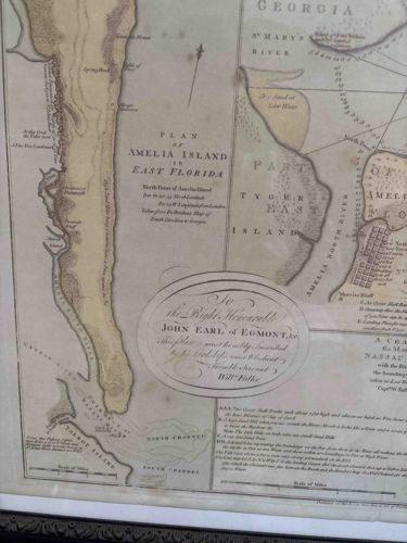
This is a detailed cartographic engraving titled 'Plan of Amelia Island in East Florida,' originally surveyed by William Fuller. The document is an important historical artifact, likely an late 18th-century or 19th-century printing of an earlier colonial-era survey. Physically, it consists of a paper substrate with hand-colored topographical features using a muted palette of ochre, tan, and subtle green washes to indicate landmasses and various water depths. The map features a decorative oval cartouche at the bottom center with elegant copperplate script that dedicates the work 'To the Right Honourable John Earl of Egmont.' Notable markings include specific geographical coordinates for the North Point of Amelia Island and a detailed legend or key describing navigation points like 'The Great Sand Banks.' The construction is typical of high-quality line engraving with cross-hatching to denote relief. Regarding condition, there is visible foxing throughout (brown spotting caused by fungal growth or paper oxidation) and significant water staining or 'tidelines' along the right edge. There appears to be a crease or potentially a repair line near the center-right. The craftsmanship is evident in the fine typography and accurate rhumb lines used for maritime navigation. The style is late Georgian, and judging by the patina and paper texture, it appears to be an antique print rather than a modern facsimile, though a physical inspection of any watermarks would be necessary for definitive dating.