AI Appraisal Estimate

AI-generated estimates · not official valuations

From the user

What was submitted

Photo and notes provided by the user — not generated by AI

Submitted item photo
Submitted photo · June 13, 2026

User's notes

No additional notes provided.

AI analysis below

AI appraisal

AI analysis & estimate

AI-Generated · Verify before acting

Everything below is generated by AI for informational purposes only. AI can make mistakes — the AI may misidentify items or misattribute them (artist, maker, brand, designer, origin, era). This is not an official valuation and should not be used for insurance, sale, tax, estate, legal, or lending purposes — or any decision requiring a certified appraisal. It is not an authoritative claim about any person, brand, or rights holder — do not share or rely on it as a factual statement about a third party. Always consult qualified professionals before making financial decisions.

Read the full disclaimer

AI Identification

·Not independently authenticated·Verify before acting

Victor Levasseur Antique Map of the Tarn-et-Garonne Department

Antique Maps and Prints

AI Estimated Value

·Not an official valuation·Verify before acting

$100 - $150

As of June 13, 2026

AI Item Analysis

·AI can make mistakes·Verify before acting
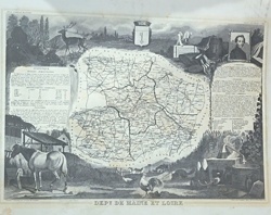
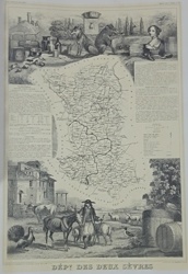
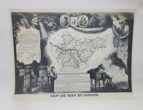
This is a mid-19th-century steel-engraved map of the French department of Tarn-et-Garonne, originally published in Victor Levasseur's 'Atlas National Illustré des 86 Départements et des Possessions de la France.' The map is characterized by its highly decorative border, which features elaborate allegorical vignettes. These illustrations include two portrait medallions at the top (likely of local historical figures), a classical river deity emerging from a cornucopia, and a representation of local industry and agriculture shown by a man tending to barrels, crates, and livestock (a horse and donkey). The central part of the engraving contains a detailed geographical map showing river systems like the Garonne and Aveyron, as well as roads and administrative divisions. Accompanying the map are blocks of text describing the statistics, climate, and commerce of the region. The print is executed in monochrome black ink on a cream-colored or off-white heavy paper stock. Notable condition issues include visible foxing and light brown staining throughout the lower margin and bottom right corner, as well as minor creasing along the outer edges that do not affect the central image. The craftsmanship represents the peak of French cartographical artistry during the 1840s to 1860s period, blending precise geography with neoclassical romantic decoration.

AI Appraisal Report

·AI can make mistakes·Verify before acting
I have virtually examined this steel-engraved map of the Tarn-et-Garonne department from Victor Levasseur's 'Atlas National Illustré.' Produced approximately circa 1845-1852, this plate epitomizes the decorative French cartographic style of the mid-19th century. The engraving displays the characteristic sharp, fine lines of a steel plate and reflects the neoclassical allegorical vignettes for which Levasseur is renowned. Based on visual cues, the item appears authentic to the period, showing correct plate-mark indentation and typical oxidation patterns of l’Imprimerie Lemercier. The item’s condition is fair to good. I observe significant foxing and moisture staining in the lower margins and right corner. While the central cartography remains largely unaffected, these biological and chemical blemishes generally reduce the value by 30-40% compared to a 'bright' or cleaned copy. Market demand for Levasseur maps remains steady due to their decorative 'frameability,' though regional maps of Tarn-et-Garonne typically command a lower price point than those of Paris or French colonial territories. Factors impacting value: The monochrome state (uncolored) is consistent with many original issues, though professionally hand-colored examples often fetch a 20% premium. The staining is the primary detractor here. Limitation Disclosure: This appraisal is based on digital imagery. A physical inspection is required to confirm the paper's watermark and ensure the staining has not compromised the fiber integrity (acidification). Full authentication would involve verifying the paper's weight and checking for modern photomechanical reproduction dots under 10x magnification, which are currently indiscernible via image. No provenance documentation was provided, which could further substantiate its history within a specific collection.

Get your items appraised

Instant estimates of your treasures with AI-powered appraisals

Browse More Appraisals