AI Item Analysis
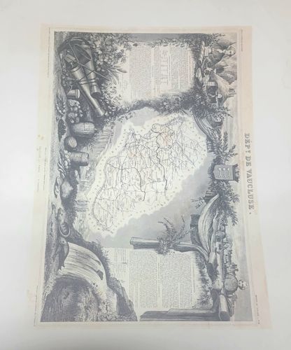
This is a 19th-century steel-plate engraving by Victor Levasseur, specifically depicting the 'Département de Vaucluse' from his renowned 'Atlas National Illustré des 86 Départements et des Possessions de la France'. The piece is printed on light-toned paper, likely a medium-weight rag paper typical of the mid-1800s. The central element is a cartographic rendering of the Vaucluse region, surrounded by an elaborate, decorative allegorical border. The border features highly detailed vignettes including regional agricultural products (vines, barrels), local landscapes, historical figures, a coat of arms, and panels of explanatory text concerning the department's statistics, history, and administration. The engraving exhibits fine-line hatching and stippling, demonstrating high-quality French craftsmanship of the period. Condition-wise, the print shows significant foxing and brown spotting across the margins and within some of the illustrated areas, which is common for paper of this age. There is visible toning and minor edge wear. The print is oriented vertically with the 'DEPT DE VAUCLUSE' title printed along the right margin. This specific style of mapping, blending geographical data with artistic sociology, was popularized by Levasseur around 1845-1854.