AI Item Analysis
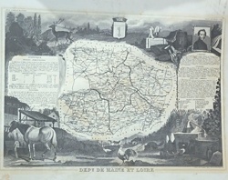
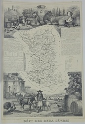
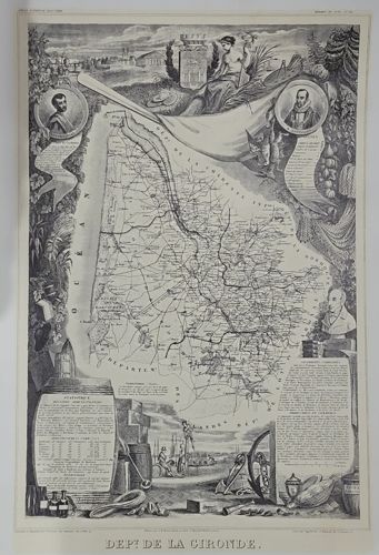
This is a detailed black-and-white steel engraving of the French department of Gironde, part of Victor Levasseur's influential 'Atlas National de la France Illustre,' typically dated circa 1845 to 1852. The central feature is a highly detailed road map of the region, flanked by the Atlantic Ocean (Ocean) and neighboring departments. The map is famously surrounded by an elaborate, allegorical vignette border that highlights the region's wealth and industry. To the bottom left, a large wine barrel is inscribed with meticulous statistical data concerning the department's population, schools, and agricultural output. Surrounding it are various bottles and tools representing the renowned Bordeaux wine trade. To the top, a female allegorical figure rests amidst a cornucopia of agricultural goods, while medallions feature notable local historical figures. The bottom right includes text boxes detailing the administration and topography of the region. The engraving demonstrates superb craftsmanship with fine cross-hatching and stippling techniques characteristic of mid-19th-century French printmaking. The paper exhibits a natural aged patina with slight yellowing, though it appears to be in good overall condition with no significant tears or foxing visible in the frame. Such prints were originally published by J. Hautecoeur in Paris and are prized for their marriage of technical cartography and decorative artistry.