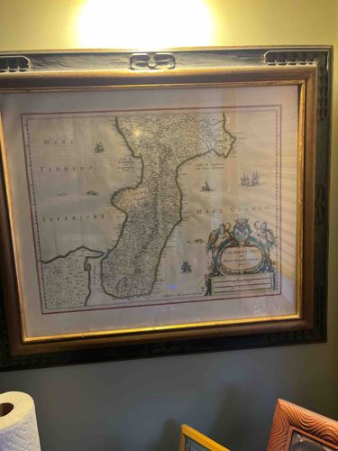
Framed Hand-Colored Map of Calabria Citra by Willem Blaeu
This item is a framed, hand-colored copperplate engraving map titled 'Calabria Citra olim Magna Graecia,' originally produced by the renowned Dutch cartographer Willem Janzsoon Blaeu circa 1640. The map displays the northern region of Calabria, Italy, bordered by the 'Mare Tirreno' (Tyrrhenian Sea) to the west and the 'Mare Jonio' (Ionian Sea) to the east. The piece features classic 17th-century cartographic elements, including a highly decorative title cartouche in the lower-right corner adorned with figures and a coat of arms. Sailing ships are scattered throughout the seas, and the topography is rendered with shaded hills and forests. The print is finished with delicate hand-coloring in pastel blues, greens, and ochres. It is housed in an ornate, dark-toned double frame: the inner frame is a narrow gilded wood profile, while the outer frame is a wider, dark wood with repeating carved motifs. The paper shows characteristic aging with a slight overall yellowing or 'toning' consistent with antiquity. There appear to be faint vertical undulations in the paper, suggesting it is not laid flat against a mounting board, which is often preferred for preserving original antique maps. The craftsmanship of the engraving remains sharp, indicating a high-quality strike from the plate. No significant foxing or water damage is immediately visible through the glazing, though the frame shows minor dust and light surface wear.
AI-Generated Appraisal Disclaimer
Estimated Value
$1,200 - $1,800
Basic Information
Category
Antique Maps and Cartography
Appraised On
February 20, 2026
Estimated Value
$1,200 - $1,800
Item Description
This item is a framed, hand-colored copperplate engraving map titled 'Calabria Citra olim Magna Graecia,' originally produced by the renowned Dutch cartographer Willem Janzsoon Blaeu circa 1640. The map displays the northern region of Calabria, Italy, bordered by the 'Mare Tirreno' (Tyrrhenian Sea) to the west and the 'Mare Jonio' (Ionian Sea) to the east. The piece features classic 17th-century cartographic elements, including a highly decorative title cartouche in the lower-right corner adorned with figures and a coat of arms. Sailing ships are scattered throughout the seas, and the topography is rendered with shaded hills and forests. The print is finished with delicate hand-coloring in pastel blues, greens, and ochres. It is housed in an ornate, dark-toned double frame: the inner frame is a narrow gilded wood profile, while the outer frame is a wider, dark wood with repeating carved motifs. The paper shows characteristic aging with a slight overall yellowing or 'toning' consistent with antiquity. There appear to be faint vertical undulations in the paper, suggesting it is not laid flat against a mounting board, which is often preferred for preserving original antique maps. The craftsmanship of the engraving remains sharp, indicating a high-quality strike from the plate. No significant foxing or water damage is immediately visible through the glazing, though the frame shows minor dust and light surface wear.
Related Tags
Get Your Items Appraised
Instant estimates of your treasures with AI-powered instant appraisals