AI Appraisal Estimate

AI-generated estimates · not official valuations

From the user

What was submitted

Photo and notes provided by the user — not generated by AI

Submitted item photo
Submitted photo · June 16, 2026

User's notes

No additional notes provided.

AI analysis below

AI appraisal

AI analysis & estimate

AI-Generated · Verify before acting

Everything below is generated by AI for informational purposes only. AI can make mistakes — the AI may misidentify items or misattribute them (artist, maker, brand, designer, origin, era). This is not an official valuation and should not be used for insurance, sale, tax, estate, legal, or lending purposes — or any decision requiring a certified appraisal. It is not an authoritative claim about any person, brand, or rights holder — do not share or rely on it as a factual statement about a third party. Always consult qualified professionals before making financial decisions.

Read the full disclaimer

AI Identification

·Not independently authenticated·Verify before acting

Antique Map of Maine-et-Loire by Victor Levasseur

Antique Maps and Prints

AI Estimated Value

·Not an official valuation·Verify before acting

$125.00 - $185.00

As of June 16, 2026

AI Item Analysis

·AI can make mistakes·Verify before acting
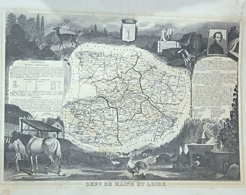
This is a mid-19th-century steel-engraved map of the French department Maine-et-Loire, specifically from Victor Levasseur's renowned 'Atlas National Illustré.' The piece is printed on heavy cream-toned paper with black ink, featuring a centrally located topographical map surrounded by elaborate, highly detailed vignettes characteristic of the Romantic era. The illustrations depict regional identity through local fauna (including a large stag, a horse, and poultry), industrial and agricultural activities (such as a distillery apparatus and farming equipment), and a portrait of a local notable in the top right corner. The top center features the departmental crest. Textual panels provide 'Statistique' (population and administrative data) and 'Célébrités' (historical figures), demonstrating the period's interest in encyclopedic knowledge. The print exhibits fine-line engraving quality with sophisticated cross-hatching and shading. Regarding condition, there is several prominent foxing spots and water staining along the upper and lower margins, along with minor yellowing consistent with an age of approximately 170 years. The margins appear uncut, though some edge wear is visible. The piece reflects the peak of French cartographic art, merging scientific geographical data with allegorical and decorative illustration.

AI Appraisal Report

·AI can make mistakes·Verify before acting
I have virtually examined this steel-engraved map of the Maine-et-Loire department from Victor Levasseur's 'Atlas National Illustré' (circa 1850). The piece displays the hallmark characteristics of Mid-19th Century French cartography, specifically the distinctive allegorical borders and encyclopedic statistics that made Levasseur’s work iconic. Authenticity appears consistent with original steel-plate impressions, evidenced by the characteristic fine-line density and standard marginal layout. The item's value is significantly impacted by its condition. While the central engraving remains legible and the ink saturation is strong, the presence of prominent foxing spots and moisture staining in the margins reduces its appeal to 'Fine' grade collectors. However, the decorative vignettes—featuring local industry and fauna—remain highly sought after for interior design purposes. Market demand for Levasseur maps remains steady due to their aesthetic appeal, though individual departments vary in rarity; Maine-et-Loire is a standard piece frequently seen in the trade. Recent auction results for similar Levasseur plates in better condition range higher, but the current staining necessitates a conservative valuation. Limitations: This appraisal is based on digital images. A physical inspection is required to confirm the presence of a plate mark, verify paper weight/watermarks, and check for light-induced acidity or thinning (skinning). To fully authenticate this as a first-edition strike rather than a later 19th-century lithographic reproduction, I would need to examine the paper under 10x magnification to identify the specific 'bite' of the steel engraving versus the flat surface of a lithograph. No provenance documentation was provided, which would further solidify its historical chain of custody.

Get your items appraised

Instant estimates of your treasures with AI-powered appraisals

Browse More Appraisals