AI Item Analysis
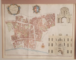
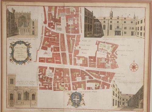
This is a hand-colored copperplate engraved map titled 'Cheap Ward with its Division into Parishes according to a new Survey,' originally produced for John Stow’s 'Survey of London.' The piece showcases a detailed street plan of the Cheap Ward district in the City of London, featuring prominent red-tinted building footprints and four inset architectural views of notable landmarks including Guildhall and St. Mildred's Church. The print is characterized by a central vertical fold line indicating its origin as a book plate. It features a decorative rococo-style title cartouche in the upper left and a heraldic crest at the bottom center, both treated with subtle hand-applied watercolor washes in blue, yellow, and red. The typography is typical of the mid-18th century, likely from the 1754-1755 edition edited by John Strype. The paper exhibits a light cream patina consistent with age, with some visible undulation and faint foxing or spotting throughout. Notable condition issues include a pronounced vertical crease from its original binding and some slight discoloration along the margins. The level of detail in the street naming and the inclusion of contemporary elevation drawings indicate high-quality 18th-century cartographic craftsmanship.