AI Appraisal Estimate

AI-generated estimates · not official valuations

From the user

What was submitted

Photo and notes provided by the user — not generated by AI

Submitted item photo
Submitted photo · June 13, 2026

User's notes

No additional notes provided.

AI analysis below

AI appraisal

AI analysis & estimate

AI-Generated · Verify before acting

Everything below is generated by AI for informational purposes only. AI can make mistakes — the AI may misidentify items or misattribute them (artist, maker, brand, designer, origin, era). This is not an official valuation and should not be used for insurance, sale, tax, estate, legal, or lending purposes — or any decision requiring a certified appraisal. It is not an authoritative claim about any person, brand, or rights holder — do not share or rely on it as a factual statement about a third party. Always consult qualified professionals before making financial decisions.

Read the full disclaimer

AI Identification

·Not independently authenticated·Verify before acting

1846 Victor Levasseur 'Carte de l'Inde' Map

Antique Maps and Cartography

AI Estimated Value

·Not an official valuation·Verify before acting

$450.00 - $650.00

As of June 13, 2026

AI Item Analysis

·AI can make mistakes·Verify before acting
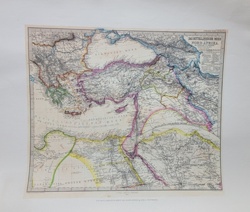
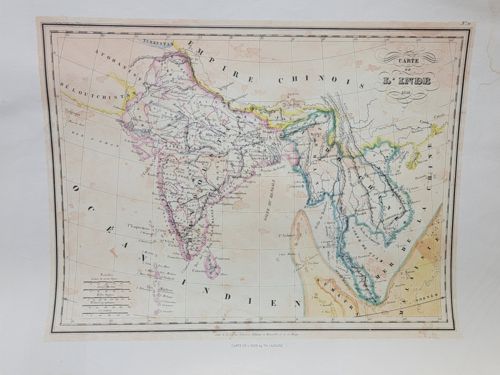
This is an original mid-19th-century engraved map titled 'Carte de l'Inde', published in 1846 by the renowned French cartographer Victor Levasseur for his noted work, the 'Atlas National Illustré'. The map is printed on cream-colored woven paper and features hand-colored outlines that delineate the various political territories of the Indian subcontinent, Southeast Asia, and parts of the Chinese Empire, including Tibet. The cartography is highly detailed for its era, showcasing topographical features like major mountain ranges, intricate river systems, and coastal details. In the upper right corner, an ornate title cartouche is visible, framed by neoclassical decorative flourishes typical of the French 'Empire' and 'Restoration' aesthetic. Small numerical scales and legends reside in the lower-left corner. The condition appears fair to good; there is evident light foxing (small brown spots) across the surface, particularly near the edges, and slight undulation of the paper sheet. Minor creasing is visible at the margins, consistent with its age and original placement in a bound atlas. The print exhibits crisp engraved lines, indicative of high-quality copperplate production. The overall aesthetic reflects the grand tradition of 19th-century French mapmaking, balancing scientific accuracy with artistic presentation.

AI Appraisal Report

·AI can make mistakes·Verify before acting
I have examined the digital representation of the 1846 Victor Levasseur 'Carte de l'Inde.' This map originates from the 'Atlas National Illustré,' a work celebrated for its distinctive aesthetic merge of cartography and decorative vignettes. Based on visual inspection, the engraving displays the characteristic sharp linework of copperplate printing. The hand-coloring appears consistent with 19th-century pigments, effectively highlighting the geopolitical boundaries of the British Raj and neighboring regions. The condition is assessed as 'Fair to Good'; notably, the foxing and paper undulation are typical of mid-19th-century wood-pulp or cotton-fiber paper stored in varied humidity. While these blemishes do detract slightly from the value compared to a 'fine' specimen, the map’s overall integrity remains high. Market demand for Levasseur maps remains stable due to their high decorative appeal. Comparables for the 'Carte de l'Inde' in similar condition typically realize between $400 and $700 at specialized auction houses. The value is bolstered by the historical significance of the Indian subcontinent during the era of the East India Company. However, the presence of foxing limits it from reaching the premium retail bracket of $1,000+. Important Note: This appraisal is based on digital images, which cannot verify paper tooth, watermark presence, or the chemical composition of the ink. A definitive authentication requires an in-person examination to confirm the absence of modern photomechanical reproduction (dots) and to check for the central fold typically found in authentic atlas maps. Provenance documentation or a microscopic analysis of the ink-bite into the paper would be necessary for a certified valuation.

Get your items appraised

Instant estimates of your treasures with AI-powered appraisals

Browse More Appraisals