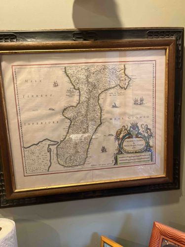
Framed 17th Century Map of Calabria Ultra by Willem Blaeu
Antique Maps and Cartography

Framed 17th Century Map of Calabria Ultra by Willem Blaeu

This item is a framed map titled 'Calabria Ultra' (the southern part of Modern Calabria, Italy), originally produced by the renowned Dutch cartographer Willem Janzsoon Blaeu circa 1635-1650. The piece demonstrates the high-quality copperplate engraving characteristic of the Golden Age of Dutch cartography. The map features the 'Mare Tirreno Inferiore' to the west and the 'Mare Jonio' to the east, populated with delicate illustrations of sailing vessels and sea monsters. A prominent, hand-colored decorative cartouche in the lower right corner displays traditional heraldic supporters and floral motifs. The map appears to be printed on laid paper, showing original fold lines consistent with historical atlas binding. It is housed in an ornate, deep-profile wood frame featuring a dark, perhaps ebonized, outer edge with relief carving and a gilded inner fillet. The paper shows a warm, aged patina with light foxing and visible undulations, suggesting it is not laid flat, which is common for authentic antique specimens. The black and gold frame appears to be a 20th-century addition, designed to complement the Baroque aesthetic of the original work. Note: While 'RC Gorman' was provided in the context, this item is a classical European map and does not depict Gorman's signature Navajo aesthetic.

Estimated Value

$1,200 - $1,800

Basic Information

Category

Antique Maps and Cartography

Appraised On

February 17, 2026

Estimated Value

$1,200 - $1,800

Additional Details Provided By Owner

User Provided Information

Rc gorman

Item Description

This item is a framed map titled 'Calabria Ultra' (the southern part of Modern Calabria, Italy), originally produced by the renowned Dutch cartographer Willem Janzsoon Blaeu circa 1635-1650. The piece demonstrates the high-quality copperplate engraving characteristic of the Golden Age of Dutch cartography. The map features the 'Mare Tirreno Inferiore' to the west and the 'Mare Jonio' to the east, populated with delicate illustrations of sailing vessels and sea monsters. A prominent, hand-colored decorative cartouche in the lower right corner displays traditional heraldic supporters and floral motifs. The map appears to be printed on laid paper, showing original fold lines consistent with historical atlas binding. It is housed in an ornate, deep-profile wood frame featuring a dark, perhaps ebonized, outer edge with relief carving and a gilded inner fillet. The paper shows a warm, aged patina with light foxing and visible undulations, suggesting it is not laid flat, which is common for authentic antique specimens. The black and gold frame appears to be a 20th-century addition, designed to complement the Baroque aesthetic of the original work. Note: While 'RC Gorman' was provided in the context, this item is a classical European map and does not depict Gorman's signature Navajo aesthetic.

Get Your Items Appraised

Instant estimates of your treasures with AI-powered instant appraisals

Browse More Appraisals