Appraisal
London Maps Appraisal
Get AI-powered appraisal estimates for your London Maps. Upload a photo for instant valuation.
Recent london maps appraisals
Antique Cartography and Historical Prints
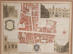
Stow's Survey of London: Cheap Ward Map
Antique Cartography & Maps
A Plan of Cow Cross and the Charter House, 1755 (Stow's Survey)

Antique Maps and Prints
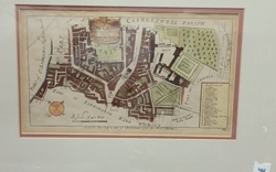
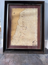
Queen-Hith Ward and Vintry Ward Map with St. Michael’s Queen-Hith Church
Maps and Cartography
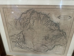
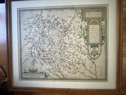
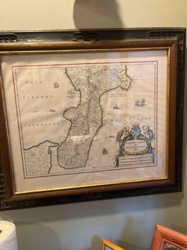
Framed antique-style engraved map of Hungary and Transylvania

Antique Maps and Cartography
Provincia di Surrey: di Nuova Projezione, Venice, 1779

Antique Maps and Prints
Antique Illustrated Lithograph Map of the Department of Tarn, France
Antique Books and Manuscripts
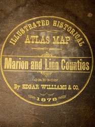
Illustrated Historical Atlas Map of Marion and Linn Counties, Oregon (1878)
Wall Art and Maps
Framed Napa Valley 'Vintage Expedition' Illustrative Map

Antique Maps and Prints
Victor Levasseur's Cartographic Engraving of the Departement de la Gironde
Prints and Art
Framed Map of Burgundy in the Style of Abraham Ortelius
Antique Cartography and Historical Prints
Stow's Survey of London: Cheap Ward Map
Antique Cartography & Maps
A Plan of Cow Cross and the Charter House, 1755 (Stow's Survey)
Antique Maps and Prints
Queen-Hith Ward and Vintry Ward Map with St. Michael’s Queen-Hith Church
Maps and Cartography
Framed antique-style engraved map of Hungary and Transylvania
Antique Maps and Cartography
Provincia di Surrey: di Nuova Projezione, Venice, 1779
Antique Maps and Prints
Antique Illustrated Lithograph Map of the Department of Tarn, France
Antique Books and Manuscripts
Illustrated Historical Atlas Map of Marion and Linn Counties, Oregon (1878)
Wall Art and Maps
Framed Napa Valley 'Vintage Expedition' Illustrative Map
Antique Maps and Prints
Victor Levasseur's Cartographic Engraving of the Departement de la Gironde
Prints and Art
Framed Map of Burgundy in the Style of Abraham Ortelius
Antique Map / Historical Print
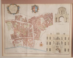
Farringdon Ward Without, with its Division into Parishes according to a New Survey (Strype's Survey of London)
Antique Cartography and Rare Prints
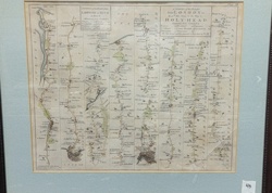
John Ogilby Britannia Road Map: London to Hith and London to Holy-Head
Art - Antique Prints and Engravings
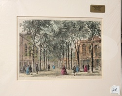
Marylebone Gardens, London (Antique Engraving)

Antique Prints and Map Art
Section of the Thames Embankment, 1867: Hand-Coloured Engraving
Maps and Cartography
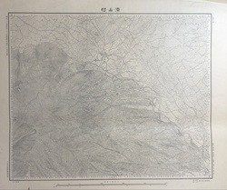
Meiji-era style Japanese topographic map of Suyama Village
Antiquarian Maps and Prints
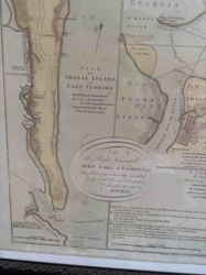
Plan of Amelia Island in East Florida by William Fuller
Antique Maps and Cartography
Framed 17th Century Map of Calabria Ultra by Willem Blaeu

Prints and Maps
Vintage city map of Florence (Firenze), Italy
Antique Maps and Cartography
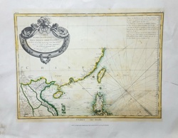
CARTE HYDRO-GEOGRAPHIQUE DES INDES ORIENTALES by Rigobert Bonne
Prints and Maps
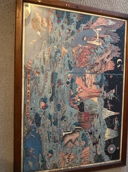
Illustrated map titled 'The Land of Make Believe' in a wooden frame
Antique Map / Historical Print
Farringdon Ward Without, with its Division into Parishes according to a New Survey (Strype's Survey of London)
Antique Cartography and Rare Prints
John Ogilby Britannia Road Map: London to Hith and London to Holy-Head
Art - Antique Prints and Engravings
Marylebone Gardens, London (Antique Engraving)
Antique Prints and Map Art
Section of the Thames Embankment, 1867: Hand-Coloured Engraving
Maps and Cartography
Meiji-era style Japanese topographic map of Suyama Village
Antiquarian Maps and Prints
Plan of Amelia Island in East Florida by William Fuller
Antique Maps and Cartography
Framed 17th Century Map of Calabria Ultra by Willem Blaeu
Prints and Maps
Vintage city map of Florence (Firenze), Italy
Antique Maps and Cartography
CARTE HYDRO-GEOGRAPHIQUE DES INDES ORIENTALES by Rigobert Bonne
Prints and Maps
Illustrated map titled 'The Land of Make Believe' in a wooden frame
Process
How our AI london maps appraisal works
- 01
Upload your photo
Take a clear photo of your london maps and upload it. One photo is all you need.
- 02
AI analysis
Our advanced AI technology analyzes your item.
- 03
Receive estimate
Get a detailed appraisal report with estimated value range, market insights, and item details.
Get the best appraisal
For the best results
- Use good lighting to capture all details
- Place item on a neutral background
- Include any identifying marks or labels
- Ensure the entire item is visible in frame
Ready to appraise your london maps?
Get your free AI-powered appraisal in under 60 seconds
No registration required · Free to use · Instant results