AI Item Analysis
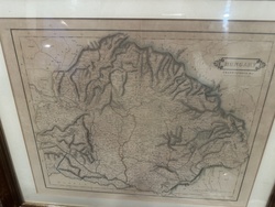
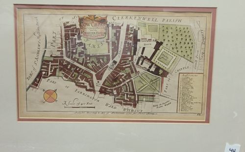
This is a mid-18th-century hand-colored copperplate engraved map titled 'Cow Cross Ward and Liberty and the Charter House', originally produced for the 1754-1755 edition of John Stow’s ‘A Survey of the Cities of London and Westminster’. The item is displayed in a landscape orientation, framed with a light-colored mat. The map features an ornate title cartouche in the upper center, a detailed key or 'Explanation' in the lower-right corner, and a compass rose at the bottom left. The layout depicts the Clerkenwell and Smithfield boundaries, including notable landmarks like the Charter House and its formal gardens. The hand-coloring uses a palette of muted greens for greenery, terrace-reds for building blocks, and yellow accents on the compass. Construction-wise, it appears to be on laid paper from the Georgian period. Regarding condition, there is visible age-toning and foxing across the surface, with a notable vertical fold line in the center corresponding to its original placement in a folio book. The ink remains sharp, indicating a good quality impression from the plate. A manufacturing inscription at the bottom indicates it was 'published according to Act of Parliament 1755 for Stow's Survey'. The level of detail in the street topography and the specialized key are indicators of high-quality mid-18th-century cartography.