AI Item Analysis
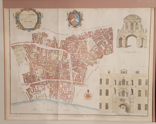
This is a hand-colored copperplate engraving representing a map of the Farringdon Ward Without in London, originally published for John Strype's 1720 edition of 'A Survey of the Cities of London and Westminster'. The map is printed on laid paper with a visible vertical center fold, consistent with its origin as an atlas or book illustration. It features a detailed street-level layout of the ward, showcasing notable landmarks like Holborn and Fleet Street, with the River Thames at the bottom. The cartography is embellished with a decorative title cartouche in the top-left corner, a coat of arms in the top center, and a compass rose. To the right of the plan are two architectural vignettes: an elevation of 'Temple Bar' and 'Blackfriars Gate'. The coloring appears to be a later hand-application, utilizing a palette of muted reds, yellows, and greens to distinguish building blocks and parks. Regarding condition, the paper shows light toning and age-related yellowing across the surface. There is a faint vertical crease from the original binding and minor edge wear. The printing remains sharp, indicating a relatively early impression from the plate. This piece is representative of early 18th-century English cartography and urban documentation, highly valued for its historical accuracy regarding the post-Great Fire layout of London.