AI Appraisal Estimate

AI-generated estimates · not official valuations

From the user

What was submitted

Photo and notes provided by the user — not generated by AI

Submitted item photo
Submitted photo · July 10, 2026

User's notes

No additional notes provided.

AI analysis below

AI appraisal

AI analysis & estimate

AI-Generated · Verify before acting

Everything below is generated by AI for informational purposes only. AI can make mistakes — the AI may misidentify items or misattribute them (artist, maker, brand, designer, origin, era). This is not an official valuation and should not be used for insurance, sale, tax, estate, legal, or lending purposes — or any decision requiring a certified appraisal. It is not an authoritative claim about any person, brand, or rights holder — do not share or rely on it as a factual statement about a third party. Always consult qualified professionals before making financial decisions.

Read the full disclaimer

AI Identification

·Not independently authenticated·Verify before acting

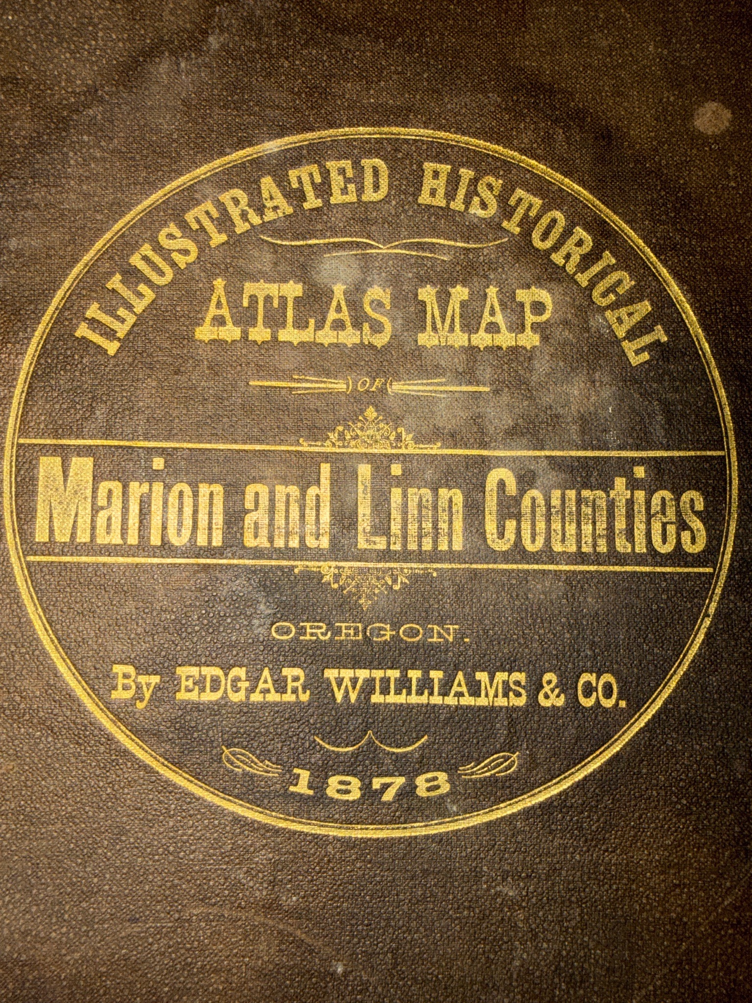
Illustrated Historical Atlas Map of Marion and Linn Counties, Oregon (1878)

Antique Books and Manuscripts

AI Estimated Value

·Not an official valuation·Verify before acting

$1,200 - $1,800 USD

As of July 10, 2026

AI Item Analysis

·AI can make mistakes·Verify before acting
The item appears to be an antique atlas, featuring a circular gilt-stamped emblem on the front cover. The cover material exhibits a dark brown, pebble-grained texture consistent with 19th-century buckram or cloth-bound book boards. The central emblem is stamped in gold-colored foil, which displays a notable aged patina and moderate rubbing, particularly on the lower edges. The text within the circular border reads verbatim: "ILLUSTRATED HISTORICAL ATLAS MAP OF Marion and Linn Counties OREGON. BY EDGAR WILLIAMS & CO. 1878". The design includes decorative flourishes and scrollwork consistent with late Victorian cartographic publishing. The surface shows visible signs of age including surface dust, minor staining at the upper right, and fading of the gilt in the '1878' date. The typography utilizes various display fonts popular in the mid-to-late 1800s. Without a physical inspection of the interior pages, binding integrity, and paper quality, this attribution to Edgar Williams & Co. in 1878 is based solely on the visible cover markings, which appear consistent with production from that era.

AI Appraisal Report

·AI can make mistakes·Verify before acting
Based on my visual examination of the cover, this item appears to be an atlas map of Marion and Linn Counties, Oregon, dated 1878. The cover displays gilt-stamped typography and flourishes consistent with late-19th-century cartographic publications by Edgar Williams & Co. However, I cannot verify the binding integrity, the presence of all lithographic plates, or the paper quality from this image alone. The value of $1,200 to $1,800 assumes the interior is complete and in good condition; nineteenth-century regional atlases are highly sought after by collectors of Pacific Northwest history. My estimate is based on the hypothesis that this is a period-produced volume. I cannot confirm the authenticity or age of the materials through a photograph, as a physical inspection would be required to rule out later facsimiles or high-quality reproductions. If the atlas were determined to be a modern reproduction or if significant interior maps are missing, the market value would likely drop below $100. To provide a more accurate valuation, an in-person examination by a rare book specialist is necessary to inspect the paper's watermark, the printing method of the maps, and the overall collation of the pages. The current market shows steady demand for early Oregoniana, though prices fluctuate significantly based on the survival of specific hand-colored plates and the absence of foxing or water damage inside.

Related Tags

Explore similar items and categories

Get your items appraised

Instant estimates of your treasures with AI-powered appraisals

Browse More Appraisals