AI identification & appraisal estimate

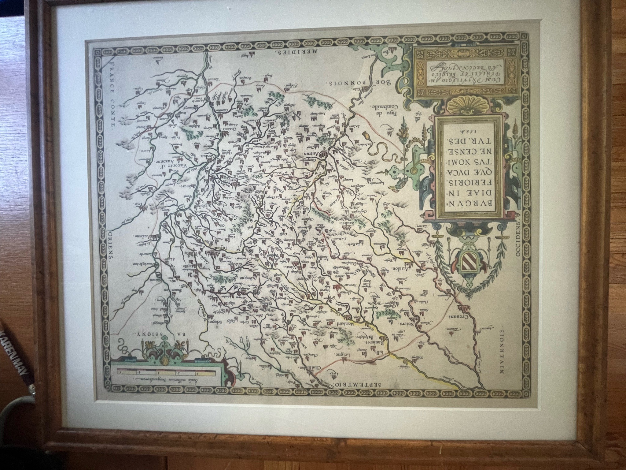
Framed Map of Burgundy in the Style of Abraham Ortelius

This name is the AI's identification of the item — it may be incorrect.

Submitted photo of Framed Map of Burgundy in the Style of Abraham Ortelius
Photo submitted by the user — not generated by AI

AI Estimated Value

Not an official valuation

$100 - $800

AI estimate as of July 26, 2026 · verify with a professional before acting

AI-Generated · Verify before acting

Everything on this page is generated by AI for informational purposes only. AI can make mistakes — the AI may misidentify items or misattribute them (artist, maker, brand, designer, origin, era). This is not an official valuation and should not be used for insurance, sale, tax, estate, legal, or lending purposes — or any decision requiring a certified appraisal. It is not an authoritative claim about any person, brand, or rights holder — do not share or rely on it as a factual statement about a third party. Always consult qualified professionals before making financial decisions.

Read the full disclaimer

AI Item Analysis

This framed wall piece features an antique-style printed map depicting the region of Burgundy (Burgundiae Inferioris). The artwork is displayed in a wooden frame with a off-white mat board surrounding the sheet. The print displays hand-colored detailing in tones of green, yellow, pink, and blue over black line work, illustrating rivers, topography, and settlements with decorative cartouches and a coat of arms. Text visible in the main cartouche reads 'BURGUNDIAE INFERIORIS, QUE DUCATUS NOMINE CENSE TUR. DES.' along with a date mark appearing as '1584'. Another upper text block mentions 'Cum Privilegio...'. The composition appears to be a reproduction or historical print consistent with 16th-century cartography, specifically works associated with Abraham Ortelius's 'Theatrum Orbis Terrarum'. The work appears in good visual condition with minimal visible discoloration, housed under glass in a simple molded wood frame. A hedged name is utilized because the item cannot be physically inspected to confirm whether it is an original period engraving, an early restrike, or a modern photomechanical reproduction.
AI Appraisal Report

Based on the image provided, I have examined this framed map depicting Burgundy (Burgundiae Inferioris), designed in the style of 16th-century cartographer Abraham Ortelius and bearing a plate date of 1584. The piece displays characteristic hand-coloring, decorative cartouches, and period-style topography. However, based on what I can see in a photograph, I cannot verify the exact age, printing method, or paper composition. A physical inspection would be required to determine whether this is an authentic 16th-century copperplate engraving, an early restrike, or a modern photomechanical reproduction. Because the exact nature of the print cannot be confirmed remotely, the value range reflects the possibilities. If an in-person examination by a paper conservator confirms this to be an authentic 16th-century hand-colored engraving from 'Theatrum Orbis Terrarum', the market value typically falls in the $500 to $800 range for maps of this specific region in good display condition. Should it prove to be a mid-to-late 20th-century decorative reproduction or offset lithograph, the fair market value would adjust to approximately $50 to $100 as a decorative wall piece. Demand for antique cartography remains steady among regional collectors and interior design buyers, though value is heavily dependent on condition, margin size, and impression quality. To establish a precise identification, an expert appraisal involving an examination of the paper watermark, plate impression marks, ink depth, and physical provenance documentation would be necessary.
Keep exploring

More prints and art appraisals

Get your items appraised

Instant AI-powered appraisal estimates from a photo

Browse More Appraisals