AI Item Analysis
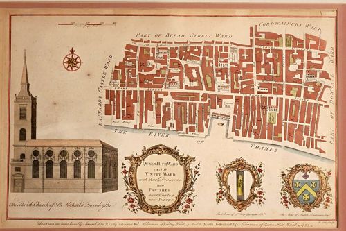
This is a hand-colored engraved historical map and architectural print dating to 1755, titled 'Queen-Hith Ward and Vintry Ward with their Divisions into Parishes according to a new Survey.' The work is likely from John Stow’s ‘Survey of London,’ significantly updated by John Strype. The item features a detailed topographical plan of the Thames-side districts of London, including Queenhithe and Vintry, with street names like Thames Street and Bow Lane clearly visible. To the left is a large, detailed elevation of ‘The Parish Church of St. Michael’s Queen-Hith,’ showing its classical Wren-style architecture and prominent spire. The lower section includes three Rococo-style decorative cartouches: a central title cartouche flanked by the arms of Sir Crisp Gascoyne and Sir Martin Dickinson, to whom the plate is dedicated as noted in the bottom script. The paper shows significant yellowing consistent with mid-18th-century rag paper, with a visible vertical fold line in the center and some minor foxing and surface staining throughout. The engraving exhibits fine linework and high-quality craftsmanship characteristic of 18th-century cartography, with hand-applied watercolor washes in red, yellow, and green used to define blocks and heraldic elements.