AI Appraisal Estimate

AI-generated estimates · not official valuations

From the user

What was submitted

Photo and notes provided by the user — not generated by AI

Submitted item photo
Submitted photo · June 16, 2026

User's notes

No additional notes provided.

AI analysis below

AI appraisal

AI analysis & estimate

AI-Generated · Verify before acting

Everything below is generated by AI for informational purposes only. AI can make mistakes — the AI may misidentify items or misattribute them (artist, maker, brand, designer, origin, era). This is not an official valuation and should not be used for insurance, sale, tax, estate, legal, or lending purposes — or any decision requiring a certified appraisal. It is not an authoritative claim about any person, brand, or rights holder — do not share or rely on it as a factual statement about a third party. Always consult qualified professionals before making financial decisions.

Read the full disclaimer

AI Identification

·Not independently authenticated·Verify before acting

Meiji-era style Japanese topographic map of Suyama Village

Maps and Cartography

AI Estimated Value

·Not an official valuation·Verify before acting

$50 - $150

As of June 16, 2026

AI Item Analysis

·AI can make mistakes·Verify before acting
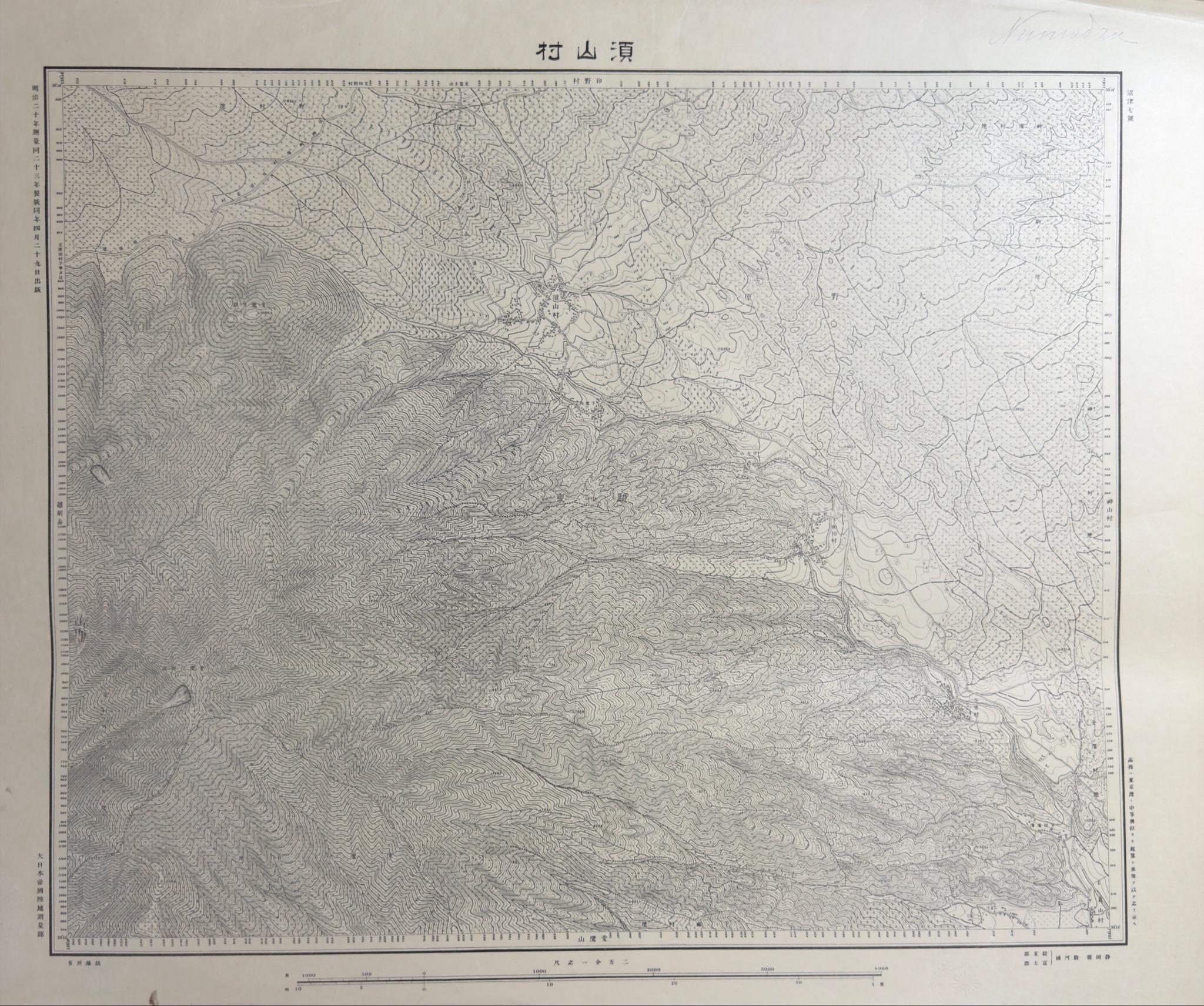
This item is a Japanese topographic map, printed in monochrome black ink on a light-colored paper substrate that shows some oxidation and light creasing consistent with age. The map illustrates mountainous terrain with dense contour lines, water drainage paths, and settlement locations. The top center bears the title "須山村" (Suyama Village). Text on the left margin includes markings consistent with a publication date of Meiji 23 (1890) and Meiji 20 (1887) survey dates, reading in part "明治二十年測量...明治二十三年...出版". The bottom left identifies the printing authority as "大日本帝國陸地測量部" (Imperial Japanese Land Survey Department). The map features a scale bar at the bottom and various topographic symbols consistent with late 19th-century cartographic standards. There is some faint pencil notation in the upper right corner and minor edge wear. The identification is based on the legible printed text on the document; however, without physical inspection of the paper and ink, it remains stylistically consistent with, rather than a definitively verified, primary source document from the stated period.

AI Appraisal Report

·AI can make mistakes·Verify before acting
Based on the provided image, I am evaluating a Japanese topographic map bearing markings consistent with a Meiji 23 (1890) publication date by the Imperial Japanese Land Survey Department. The map depicts Suyama Village with dense contour lines and settlement locations. From what I can see, the paper substrate shows oxidation, light creasing, minor edge wear, and faint pencil notations consistent with age. However, I cannot evaluate the physical properties of the ink or paper from a photograph. Therefore, this assessment treats the item as a period-style document rather than an established primary source. The value estimate of $50 to $150 reflects the general market demand for comparable late 19th-century Japanese cartographic materials, assuming the attribution to the stated period is accurate. Late Meiji military and topographic maps hold steady interest among specialized collectors. If in-person examination of the printing method and paper fibers indicates this is a later reproduction or modern copy, the value would drop to approximately $10 to $25 as a decorative item. A full physical inspection by a specialist in East Asian cartography would be needed to assess its true age and printing era.

Get your items appraised

Instant estimates of your treasures with AI-powered appraisals

Browse More Appraisals