AI Appraisal Estimate

AI-generated estimates · not official valuations

From the user

What was submitted

Photo and notes provided by the user — not generated by AI

Submitted item photo
Submitted photo · June 13, 2026

User's notes

No additional notes provided.

AI analysis below

AI appraisal

AI analysis & estimate

AI-Generated · Verify before acting

Everything below is generated by AI for informational purposes only. AI can make mistakes — the AI may misidentify items or misattribute them (artist, maker, brand, designer, origin, era). This is not an official valuation and should not be used for insurance, sale, tax, estate, legal, or lending purposes — or any decision requiring a certified appraisal. It is not an authoritative claim about any person, brand, or rights holder — do not share or rely on it as a factual statement about a third party. Always consult qualified professionals before making financial decisions.

Read the full disclaimer

AI Identification

·Not independently authenticated·Verify before acting

CARTE HYDRO-GEOGRAPHIQUE DES INDES ORIENTALES by Rigobert Bonne

Antique Maps and Cartography

AI Estimated Value

·Not an official valuation·Verify before acting

$450 - $650

As of June 13, 2026

AI Item Analysis

·AI can make mistakes·Verify before acting
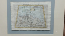
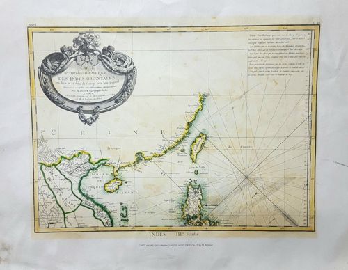
This is a hand-colored antique engraved map titled 'CARTE HYDRO-GEOGRAPHIQUE DES INDES ORIENTALES', focused on the coasts of China, Taiwan (Formose), and Southeast Asia. The map is an authentic copperplate engraving, likely dating to the late 18th century, circa 1770-1780, authored by Rigobert Bonne, the Royal Hydrographer to the French King. The piece features a prominent Baroque-style title cartouche in the upper left corner, adorned with ornate scrollwork and garlands. The coastline is highlighted with greenish-yellow professional hand-coloring. Notable geographical features include 'CHINE', 'Isle Formose', and the 'Golfe de la Sonde'. Rhumb lines emanate from a central point, emphasizing its utility as a nautical or hydrographic chart. The paper shows signs of age-related toning, minor foxing (brown spotting), and some faint creasing. The print is contained within a simple double-line border with latitude and longitude markings. A block of French text occupies the upper right quadrant, detailing maritime notes. The overall craftsmanship reflects the high standards of French cartography during the Enlightenment, displaying fine line work and clear typography.

AI Appraisal Report

·AI can make mistakes·Verify before acting
Based on my visual examination of this copperplate engraving, I identify it as an authentic 18th-century hydrographic chart by Rigobert Bonne, likely from his contribution to the 'Atlas de toutes les parties connues du globe terrestre' (c. 1780). The work exhibits the characteristic fine-lined precision of French Enlightenment cartography. The presence of a classic Baroque cartouche and the specific plate's 'hydro-geographique' focus makes it a desirable specimen for collectors of Asian maritime history, specifically for its depictions of Formosa (Taiwan) and the South China Sea. The condition appears fair to good. I note significant age-toning and visible foxing in the upper quadrants, which is typical for paper of this period but slightly suppresses the value compared to a pristine 'washed' example. The hand-coloring is professionally applied and consistent with 18th-century palettes. Market demand for Bonne maps remains stable. While Bonne was prolific, his charts of the East Indies and China consistently outperform his European or American inland maps due to the high interest in colonial trade routes. Recent auction results for similar hand-colored Bonne charts range from $400 to $700 depending on margin health and centering. Limitations: My assessment is based on high-resolution imagery. Full authentication requires an in-person inspection to verify the watermark (e.g., 'bouteille' or 'grappe de raisins'), paper weight, and the presence of a central fold consistent with atlas binding. I would also need to examine the verso for historical annotations or previous mounting residue. Provenance documentation or a record of acquisition from a reputable map dealer would further solidify this valuation.

Get your items appraised

Instant estimates of your treasures with AI-powered appraisals

Browse More Appraisals