Appraisal
Victor Levasseur Atlas National Illustre Map Of The Department Of Aude France Appraisal
Get AI-powered appraisal estimates for your Victor Levasseur Atlas National Illustre Map Of The Department Of Aude France. Upload a photo for instant valuation.
Recent victor levasseur atlas national illustre map of the department of aude france appraisals

Antique Cartography and Prints
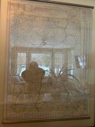
Victor Levasseur 'Atlas National Illustré' Map of the Department of Aude, France
Antique Cartography and Fine Art Prints
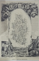
Victor Levasseur Illustrative Map of Dépt. de la Meuse (Atlas National Illustré)
Antique Cartography & Prints
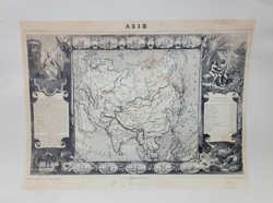
Levasseur Antique Map of Asia (Asie) from the 'Atlas National Illustre'
Antique Maps and Prints
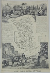
Antiquarian Map of the Département des Deux-Sèvres from Atlas National Illustré

Antique Maps and Prints
Victor Levasseur Map of the Département de Vaucluse

Antique Cartography and Art Prints
Victor Levasseur's Cartographic Engraving of the Département de Vaucluse

Antique Maps and Prints
Victor Levasseur's Cartographic Engraving of the Departement de la Gironde
Book/Atlas
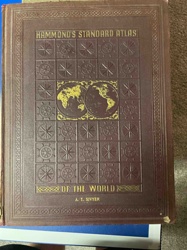
Hammond's Standard Atlas of the World
Wall Decor / Cartography
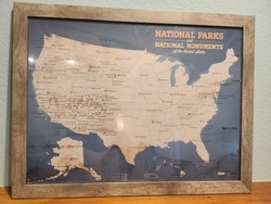
Framed National Parks and National Monuments Map of the United States

Antique Prints and Map Art
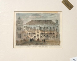
Section of the Thames Embankment, 1867: Hand-Coloured Engraving
Antique Cartography and Prints
Victor Levasseur 'Atlas National Illustré' Map of the Department of Aude, France
Antique Cartography and Fine Art Prints
Victor Levasseur Illustrative Map of Dépt. de la Meuse (Atlas National Illustré)
Antique Cartography & Prints
Levasseur Antique Map of Asia (Asie) from the 'Atlas National Illustre'
Antique Maps and Prints
Antiquarian Map of the Département des Deux-Sèvres from Atlas National Illustré
Antique Maps and Prints
Victor Levasseur Map of the Département de Vaucluse
Antique Cartography and Art Prints
Victor Levasseur's Cartographic Engraving of the Département de Vaucluse
Antique Maps and Prints
Victor Levasseur's Cartographic Engraving of the Departement de la Gironde
Book/Atlas
Hammond's Standard Atlas of the World
Wall Decor / Cartography
Framed National Parks and National Monuments Map of the United States
Antique Prints and Map Art
Section of the Thames Embankment, 1867: Hand-Coloured Engraving
Antique Cartography and Prints
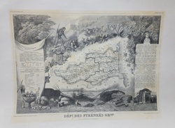
Victor Levasseur Atlas National Illustré: Dépt des Pyrénées Orles
Antique Cartography and Prints
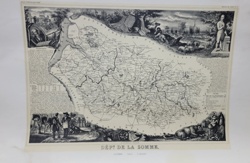
Victor Levasseur's 'Département de la Somme' Map from Atlas National Illustré

Antique Maps and Prints
Victor Levasseur Antique Map of the Tarn-et-Garonne Department

Antique Cartography and Ephemera
Carte Physique et Minéralogique de la France (1862) by Victor Levasseur

Antique Maps and Cartography
1846 Victor Levasseur 'Carte de l'Inde' Map
Antique Maps and Prints
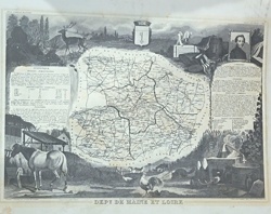
Antique Map of Maine-et-Loire by Victor Levasseur

Antique Maps and Prints
Antique Illustrated Lithograph Map of the Department of Tarn, France

Book
The Explorer World Atlas by Rand McNally (Port of Portland Edition)
Antique Cartography and Vintage Paper Ephemera
The Official Map of Vermont and New Hampshire by National Survey
Art & Antiquarian Prints
Antiquarian Hand-Colored Engraving of The Scotch National Church, Crown Court
Antique Cartography and Prints
Victor Levasseur Atlas National Illustré: Dépt des Pyrénées Orles
Antique Cartography and Prints
Victor Levasseur's 'Département de la Somme' Map from Atlas National Illustré
Antique Maps and Prints
Victor Levasseur Antique Map of the Tarn-et-Garonne Department
Antique Cartography and Ephemera
Carte Physique et Minéralogique de la France (1862) by Victor Levasseur
Antique Maps and Cartography
1846 Victor Levasseur 'Carte de l'Inde' Map
Antique Maps and Prints
Antique Map of Maine-et-Loire by Victor Levasseur
Antique Maps and Prints
Antique Illustrated Lithograph Map of the Department of Tarn, France
Book
The Explorer World Atlas by Rand McNally (Port of Portland Edition)
Antique Cartography and Vintage Paper Ephemera
The Official Map of Vermont and New Hampshire by National Survey
Art & Antiquarian Prints
Antiquarian Hand-Colored Engraving of The Scotch National Church, Crown Court
Process
How our AI victor levasseur atlas national illustre map of the department of aude france appraisal works
- 01
Upload your photo
Take a clear photo of your victor levasseur atlas national illustre map of the department of aude france and upload it. One photo is all you need.
- 02
AI analysis
Our advanced AI technology analyzes your item.
- 03
Receive estimate
Get a detailed appraisal report with estimated value range, market insights, and item details.
Get the best appraisal
For the best results
- Use good lighting to capture all details
- Place item on a neutral background
- Include any identifying marks or labels
- Ensure the entire item is visible in frame
Ready to appraise your victor levasseur atlas national illustre map of the department of aude france?
Get your free AI-powered appraisal in under 60 seconds
No registration required · Free to use · Instant results