Appraisal
Old Maps Appraisal
Get AI-powered appraisal estimates for your Old Maps. Upload a photo for instant valuation.
Recent old maps appraisals

Antique Maps and Cartography
Provincia di Surrey: di Nuova Projezione, Venice, 1779
Antiquarian Maps and Prints
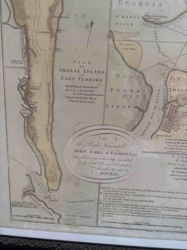
Plan of Amelia Island in East Florida by William Fuller
Antique Map
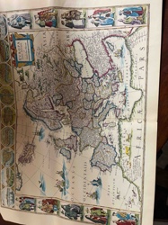
Antique Hand-Colored Map of Europa (Europe)

Antique Maps and Prints
Queen-Hith Ward and Vintry Ward Map with St. Michael’s Queen-Hith Church
Antiques & Collectibles - Maps and Cartography
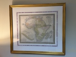
Map of Africa from the Latest Authorities by Thomas, Cowperthwait & Co.

Antique Maps
Vintage Lake Minnetonka Map
Antique Cartography and Prints
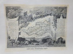
Victor Levasseur Atlas National Illustré: Dépt des Pyrénées Orles

Antique Maps and Ephemera
Monde Connu Des Anciens Map
Art and Collectibles - Cartography / Wall Decor
Framed Reproductions of Visscher and Hondius Maps of America
Cartographic Reproductions & Ephemera
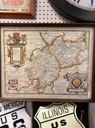
Reproduction Saxton's Map of Warwickshire and Leicestershire
Antique Maps and Cartography
Provincia di Surrey: di Nuova Projezione, Venice, 1779
Antiquarian Maps and Prints
Plan of Amelia Island in East Florida by William Fuller
Antique Map
Antique Hand-Colored Map of Europa (Europe)
Antique Maps and Prints
Queen-Hith Ward and Vintry Ward Map with St. Michael’s Queen-Hith Church
Antiques & Collectibles - Maps and Cartography
Map of Africa from the Latest Authorities by Thomas, Cowperthwait & Co.
Antique Maps
Vintage Lake Minnetonka Map
Antique Cartography and Prints
Victor Levasseur Atlas National Illustré: Dépt des Pyrénées Orles
Antique Maps and Ephemera
Monde Connu Des Anciens Map
Art and Collectibles - Cartography / Wall Decor
Framed Reproductions of Visscher and Hondius Maps of America
Cartographic Reproductions & Ephemera
Reproduction Saxton's Map of Warwickshire and Leicestershire
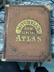
Books and Manuscripts
Large-format world atlas titled 'Mitchell's New General Atlas'
Antique Maps and Cartography
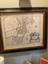
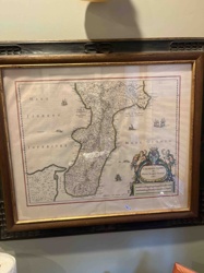
Framed 17th Century Map of Calabria Ultra by Willem Blaeu

Antique Cartography and Paper Ephemera
Antiquarian Map: Russie d'Europe, 1850

Antique Maps and Prints
Victor Levasseur's Cartographic Engraving of the Departement de la Gironde

Antique Maps
Antique World Map
Antique Map Reproductions / Cartography
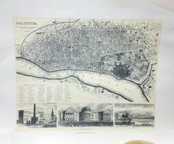
Antiquarian Map of Calcutta and the Hoogly River
Antique Maps and Cartography
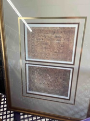
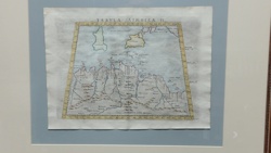
Ptolemaic Map of North Africa (Tabula Aphricae II)
Antiques & Collectibles - Cartography
Calabria Citra framed antique-style map

Map
Vintage China Map

Antique Cartography and Printed Maps
A New & Accurate Map of North America (c. 1790s)
Books and Manuscripts
Large-format world atlas titled 'Mitchell's New General Atlas'
Antique Maps and Cartography
Framed 17th Century Map of Calabria Ultra by Willem Blaeu
Antique Cartography and Paper Ephemera
Antiquarian Map: Russie d'Europe, 1850
Antique Maps and Prints
Victor Levasseur's Cartographic Engraving of the Departement de la Gironde
Antique Maps
Antique World Map
Antique Map Reproductions / Cartography
Antiquarian Map of Calcutta and the Hoogly River
Antique Maps and Cartography
Ptolemaic Map of North Africa (Tabula Aphricae II)
Antiques & Collectibles - Cartography
Calabria Citra framed antique-style map
Map
Vintage China Map
Antique Cartography and Printed Maps
A New & Accurate Map of North America (c. 1790s)
Process
How our AI old maps appraisal works
- 01
Upload your photo
Take a clear photo of your old maps and upload it. One photo is all you need.
- 02
AI analysis
Our advanced AI technology analyzes your item.
- 03
Receive estimate
Get a detailed appraisal report with estimated value range, market insights, and item details.
Get the best appraisal
For the best results
- Use good lighting to capture all details
- Place item on a neutral background
- Include any identifying marks or labels
- Ensure the entire item is visible in frame
Ready to appraise your old maps?
Get your free AI-powered appraisal in under 60 seconds
No registration required · Free to use · Instant results