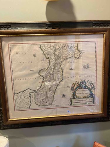
Calabria Citra framed antique-style map
This item is a framed, hand-colored map of 'Calabria Citra' (Northern Calabria, Italy), originally based on the cartographic work of Magini. The map depicts the southern Italian peninsula flanked by the 'Mare Tirreno Inferiore' to the west and the 'Mare Ionio' to the east. It features a detailed topographical rendering of the mountainous interior, coastal towns, and several small sailing vessels in the surrounding waters. A prominent, decorative cartouche is located in the bottom right corner, featuring a coat of arms flanked by two figures and a crown, with the title 'CALABRIA CITRA ol: Altera Magna Græcia pars' inscribed within. The map is printed on what appears to be a light-colored paper which shows significant signs of rippling or 'cockling,' likely due to humidity or improper mounting. There is a visible horizontal fold line across the center typically found in maps originally bound in atlases. It is housed under glass in a traditional dark wood frame with a gilded inner lip. The frame shows minor surface wear. While the design is based on 17th-century cartography, the brightness of the colors and the crispness of certain lines suggest this could be a high-quality mid-20th-century reproduction or a well-preserved later strike, as an original 1600s engraving would typically exhibit deeper foxing and more distinct copperplate indentations not readily visible here.
AI-Generated Appraisal Disclaimer
Estimated Value
$150 - $250
Basic Information
Category
Antiques & Collectibles - Cartography
Appraised On
February 17, 2026
Estimated Value
$150 - $250
Item Description
This item is a framed, hand-colored map of 'Calabria Citra' (Northern Calabria, Italy), originally based on the cartographic work of Magini. The map depicts the southern Italian peninsula flanked by the 'Mare Tirreno Inferiore' to the west and the 'Mare Ionio' to the east. It features a detailed topographical rendering of the mountainous interior, coastal towns, and several small sailing vessels in the surrounding waters. A prominent, decorative cartouche is located in the bottom right corner, featuring a coat of arms flanked by two figures and a crown, with the title 'CALABRIA CITRA ol: Altera Magna Græcia pars' inscribed within. The map is printed on what appears to be a light-colored paper which shows significant signs of rippling or 'cockling,' likely due to humidity or improper mounting. There is a visible horizontal fold line across the center typically found in maps originally bound in atlases. It is housed under glass in a traditional dark wood frame with a gilded inner lip. The frame shows minor surface wear. While the design is based on 17th-century cartography, the brightness of the colors and the crispness of certain lines suggest this could be a high-quality mid-20th-century reproduction or a well-preserved later strike, as an original 1600s engraving would typically exhibit deeper foxing and more distinct copperplate indentations not readily visible here.
Related Tags
Get Your Items Appraised
Instant estimates of your treasures with AI-powered instant appraisals