Photo and notes provided by the user — not generated by AI
Submitted photo · July 12, 2026
User's notes
No additional notes provided.
AI analysis below
AI appraisal
AI analysis & estimate
AI-Generated · Verify before acting
Everything below is generated by AI for informational purposes only. AI can make mistakes — the AI may misidentify items or misattribute them (artist, maker, brand, designer, origin, era). This is not an official valuation and should not be used for insurance, sale, tax, estate, legal, or lending purposes — or any decision requiring a certified appraisal. It is not an authoritative claim about any person, brand, or rights holder — do not share or rely on it as a factual statement about a third party. Always consult qualified professionals before making financial decisions.
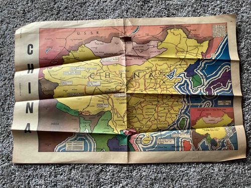
This item is a folded paper map depicting China and surrounding regions, including parts of the U.S.S.R., Mongolia, India, and Southeast Asia. The map is printed in color on potentially thin paper, exhibiting significant creasing and folding lines, indicating it was likely stored or issued in a folded state. The colors used for different regions and geographical features are varied, including yellow, green, pink, blue, and shades of brown. The map includes numerous place names and appears to show political boundaries and possibly some transportation routes, such as railroads. There are inset boxes or sections providing additional information or details, including one that appears to be a key explaining symbols or colors. There are visible signs of wear, including discoloration, creasing, and possibly some minor tears or edge damage along the folds and edges. The overall condition suggests age and use. The style of the cartography and the geopolitical boundaries depicted suggest it is likely from the mid-20th century, possibly related to a specific historical period or event given the level of detail and focus on this region. There do not appear to be any clearly discernible maker's marks or signatures in the visible area of the map, but a closer examination for such details would be necessary for a complete assessment of its origin and exact age.
AI Appraisal Report
·AI can make mistakes·Verify before acting
Upon visual examination of the provided image, I assess this folded color map of China and surrounding regions to be a vintage piece, likely from the mid-20th century based on the political boundaries and cartographic style. The paper appears thin, consistent with common printing practices for maps designed for distribution or reference during that era. The condition is fair to poor, exhibiting significant creasing from folding, discoloration consistent with age, and potential minor tears or edge wear along the folds. The presence of inset boxes, including what appears to be a key, suggests it was a detailed and informative map for its time. Authenticity is strongly suggested by the observed physical characteristics corresponding to age, though without in-person examination, I cannot definitively rule out later reproductions based solely on the image. Market conditions for vintage paper ephemera, particularly regional maps, are variable and depend heavily on subject matter, condition, and rarity. While historical maps of China are collected, the condition significantly impacts the potential value of this particular example. Comparables in better condition might reach higher values, but the wear on this piece limits its desirability. Demand for such a specific regional map depends on interest from collectors of historical maps, Asian history enthusiasts, and potentially military or political historians. Its rarity is difficult to ascertain from the image alone; it could be a common issue or a more specialized publication. Factors significantly impacting value are its condition, exact age and publisher (undetermined from the image), and specific historical context it represents. For full authentication, an in-person examination is crucial to assess paper type, printing process, and check for watermarks or publisher's marks not visible in the image. Analysis of the specific geopolitical boundaries depicted could help date it more precisely. Provenance documentation, if available, would also greatly contribute to establishing authenticity and potentially value.