AI Item Analysis
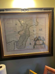
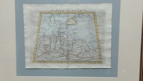
This is a framed, hand-colored antique map titled 'TABVLA APPHRICAE II', likely a copperplate engraving from a 16th-century edition of Claudius Ptolemy's 'Geographia'. The map depicts North Africa, specifically the region of modern-day Libya and surrounding areas, emphasizing the coastline and river systems. It features a trapezoidal border with degrees of latitude and longitude marked. The map is printed on laid paper with visible chain lines and a slightly irregular edge. Notable features include topographical representations of mountains using stylized 'sugar-loaf' illustrations and Latin inscriptions for various tribes and locations. The coloring is hand-applied, primarily using soft blues for water bodies and yellow ochre for the borders and land outlines. Condition issues include visible vertical and horizontal fold lines from its original insertion into an atlas, minor foxing throughout the paper, and slight waviness in the paper substrate. The craftsmanship reflects the Renaissance period of cartography, focusing on classical knowledge rediscovered during that era. It is presented within a light blue double mat and a dark frame, which appears to be a modern conservation mounting.