AI Item Analysis
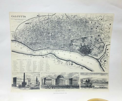
This item is a detailed monochromatic print of an antiquarian map depicting Calcutta (now Kolkata), India, and the adjacent River Hoogly. The map is printed on a rectangular cream-colored paper stock with black ink. The upper portion features a high-density topographical plan of the city, showing street layouts, various plots of land, and a prominent star-fort design representing Fort William. Below the map, there is a comprehensive 'References to the Public Buildings' index organized into columns, as well as several topographical vignettes along the bottom edge showing architectural landmarks such as 'The Government House' and waterfront scenes. The text is crisp and reflects 19th-century typography. The print appears to be a modern or mid-20th-century reproduction of an 1842 original, indicated by the small caption 'CALCUTTA IN 1842' centered at the very bottom margin. Physically, the paper shows minor toning consistent with age but lacks significant foxing, heavy creasing, or tearing, suggesting it has been well-preserved or is of more recent manufacture. The linework is fine, indicative of lithographic or high-quality offset printing techniques designed to emulate historical steel engravings. The composition is balanced, combining cartographic precision with artistic illustrations of colonial-era architecture.