AI estimate as of September 17, 2025 · verify with a professional before acting
AI-Generated · Verify before acting
Everything on this page is generated by AI for informational purposes only. AI can make mistakes — the AI may misidentify items or misattribute them (artist, maker, brand, designer, origin, era). This is not an official valuation and should not be used for insurance, sale, tax, estate, legal, or lending purposes — or any decision requiring a certified appraisal. It is not an authoritative claim about any person, brand, or rights holder — do not share or rely on it as a factual statement about a third party. Always consult qualified professionals before making financial decisions.
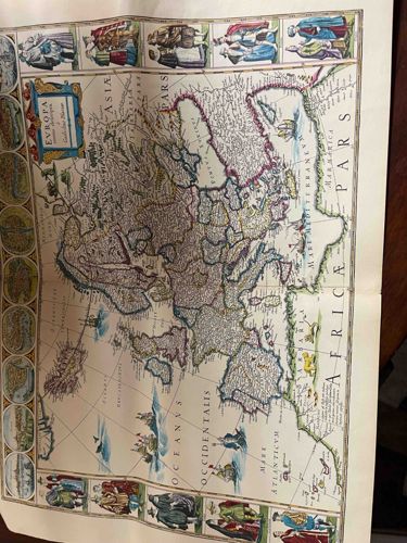
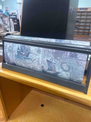
This item is an antique, hand-colored copperplate engraved map titled 'EVROPA' with additional text below, likely indicating the publisher or cartographer and possibly the edition. The map depicts the continent of Europe, showing intricate geographical details including mountain ranges, rivers, and numerous cities and towns. The political boundaries of various regions and countries are delineated and partially highlighted with delicate hand-coloring in hues of green, pink, yellow, and blue. The oceans are rendered in a light blue wash, featuring several sailing ships and sea monsters, typical decorative elements of maps from this period.
Distinguishing features include an elaborate cartouche in the upper left corner with the title, framed by decorative elements. Along the top and bottom borders, and the left vertical border, there are highly detailed illustrations of various figures in traditional dress, representing different nations or societal types. Along the left vertical margin, circular vignettes likely depict notable cities or landscapes. The text 'ASIA PARS' appears to the right of Russia and 'AFRICA' along the southern coast, indicating the adjacent continents. The 'MARE ATLANTICUM' and 'OCEANUS OCCIDENTALIS' label the Atlantic Ocean. The overall aesthetic suggests a 17th or early 18th-century origin, a period when mapmaking was both a science and an art form. The paper appears to be laid paper, characteristic of older printed materials, and exhibits some creasing and possibly fold marks, suggesting it may have been bound in an atlas at some point. The colors are generally vibrant for their age, indicating good preservation, though slight toning or minor foxing might be present upon closer inspection. The craftsmanship is high, with fine engraving lines visible in the geographical details and the decorative elements.
AI Appraisal Report
Based on my visual examination of the provided image, this hand-colored copperplate engraved map, 'EVROPA', appears to be an authentic and well-preserved example from the 17th or early 18th century. The intricate geographical details, elaborate cartouche, presence of sailing ships and sea monsters, and especially the detailed border illustrations of figures in traditional dress and circular vignettes, are all highly indicative of a map produced during this period, likely by a prominent Dutch or French cartographer. The hand-coloring appears original and vibrant for its age, suggesting good preservation, although without physical inspection, minor toning or foxing cannot be ruled out. The visible creasing and potential fold marks suggest it was likely bound in an atlas, which is common and generally does not significantly detract from value unless severe.
From a market perspective, highly decorative and detailed maps of Europe from this era are consistently in demand by collectors. Scarce examples by renowned cartographers (e.g., Blaeu, Hondius, Sanson) command significant prices. The decorative border elements particularly enhance its aesthetic appeal and rarity, distinguishing it from simpler historical maps. My valuation is based on comparables for similar early European maps with extensive decorative elements sold at reputable auction houses and by specialist dealers. The proposed range reflects the good apparent condition and detailed artistry.
However, it's crucial to note that this is a preliminary assessment based solely on the image. Full authentication would require in-person examination to verify paper type (laid paper characteristics), printing method, and the originality of the hand-coloring. Magnification would reveal engraving plate marks and any repairs. Provenance documentation, if available, would significantly enhance certainty and potentially value. Without physical inspection, I cannot definitively rule out later reprints, although the overall aesthetic strongly suggests authenticity. Scientific testing of pigments and paper might also be beneficial.