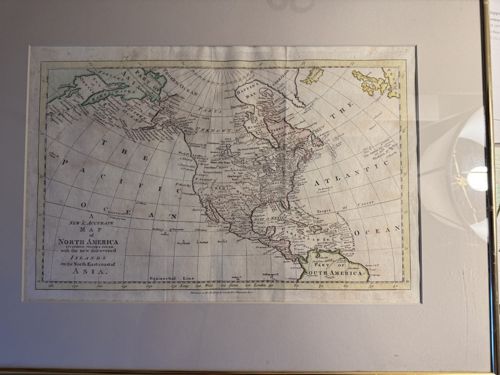
A New & Accurate Map of North America (c. 1790s)
Antique Cartography and Printed Maps

A New & Accurate Map of North America (c. 1790s)

This is a hand-colored copperplate engraved map titled 'A New & Accurate Map of North America: drawn from the latest authorities with the new discovered Islands on the North East coast of Asia.' The map depicts the North American continent, Central America, and the Caribbean, notably featuring an incomplete Pacific Northwest and the mythical 'River of the West.' It includes a cartouche in the lower-left corner with various topographical details and text. The map is printed on laid paper, showing characteristic vertical fold lines, indicating it likely originated as a supplement in an 18th-century geographical publication or atlas. The coloring consists of light pastel washes in pink, yellow, and green, used to define territorial boundaries and coastal regions. Measuring approximately 10 by 14 inches (sight), it is housed in a modern matted frame with a simple metallic gilt edge. Condition-wise, the paper shows minor toning consistent with age, several visible vertical creases from its original binding, and some slight rippling under the glass. The engraving displays fine craftsmanship with delicate lettering and crisp line work, typical of late 18th-century cartography from English or European mapmakers like Thomas Conder or William Russell. The presence of the 'Parts Unknown' in the Northwest and the inclusion of Captain Cook's discoveries place this map's production in the post-1780 era.

Estimated Value

$450 - $650

Basic Information

Category

Antique Cartography and Printed Maps

Appraised On

February 28, 2026

Estimated Value

$450 - $650

Item Description

This is a hand-colored copperplate engraved map titled 'A New & Accurate Map of North America: drawn from the latest authorities with the new discovered Islands on the North East coast of Asia.' The map depicts the North American continent, Central America, and the Caribbean, notably featuring an incomplete Pacific Northwest and the mythical 'River of the West.' It includes a cartouche in the lower-left corner with various topographical details and text. The map is printed on laid paper, showing characteristic vertical fold lines, indicating it likely originated as a supplement in an 18th-century geographical publication or atlas. The coloring consists of light pastel washes in pink, yellow, and green, used to define territorial boundaries and coastal regions. Measuring approximately 10 by 14 inches (sight), it is housed in a modern matted frame with a simple metallic gilt edge. Condition-wise, the paper shows minor toning consistent with age, several visible vertical creases from its original binding, and some slight rippling under the glass. The engraving displays fine craftsmanship with delicate lettering and crisp line work, typical of late 18th-century cartography from English or European mapmakers like Thomas Conder or William Russell. The presence of the 'Parts Unknown' in the Northwest and the inclusion of Captain Cook's discoveries place this map's production in the post-1780 era.

Get Your Items Appraised

Instant estimates of your treasures with AI-powered instant appraisals

Browse More Appraisals