AI Item Analysis
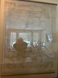
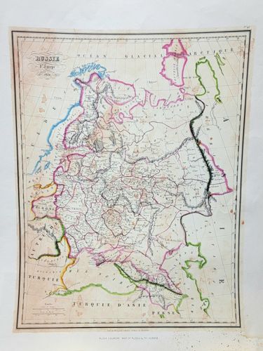
This is a detailed 19th-century engraved map titled 'Russie d'Europe' (Russia in Europe), dated 1850. The piece is a copper-plate or steel-plate engraving on medium-weight off-white paper, featuring hand-colored borders in vibrant shades of pink, green, blue, and yellow to delineate various regions and national boundaries. The map shows the Russian Empire's western extent, including parts of Eastern Europe, the Ural Mountains, and bordering regions of Turkey (Turquie d'Asie) and Persia. An ornate title cartouche is visible in the upper left corner, while a distance scale and topographical notations appear at the bottom. The cartography exhibits fine linework characteristic of the mid-19th century, likely from a French atlas such as those by Victor Levasseur or similar contemporaries. The condition of the map shows moderate signs of age; there is visible foxing (brown spotting) concentrated toward the lower-right margin and light overall toning of the paper. Hand-coloration appears largely intact though slightly faded in some areas. There are minor creases and a soft vertical fold line suggesting it was once part of a bound volume. The edges appear slightly uneven, consistent with an authentic extraction from an antique atlas. Its craftsmanship is evidenced by the precision of the engraved hydrography and the elegant serif typography used for place names.