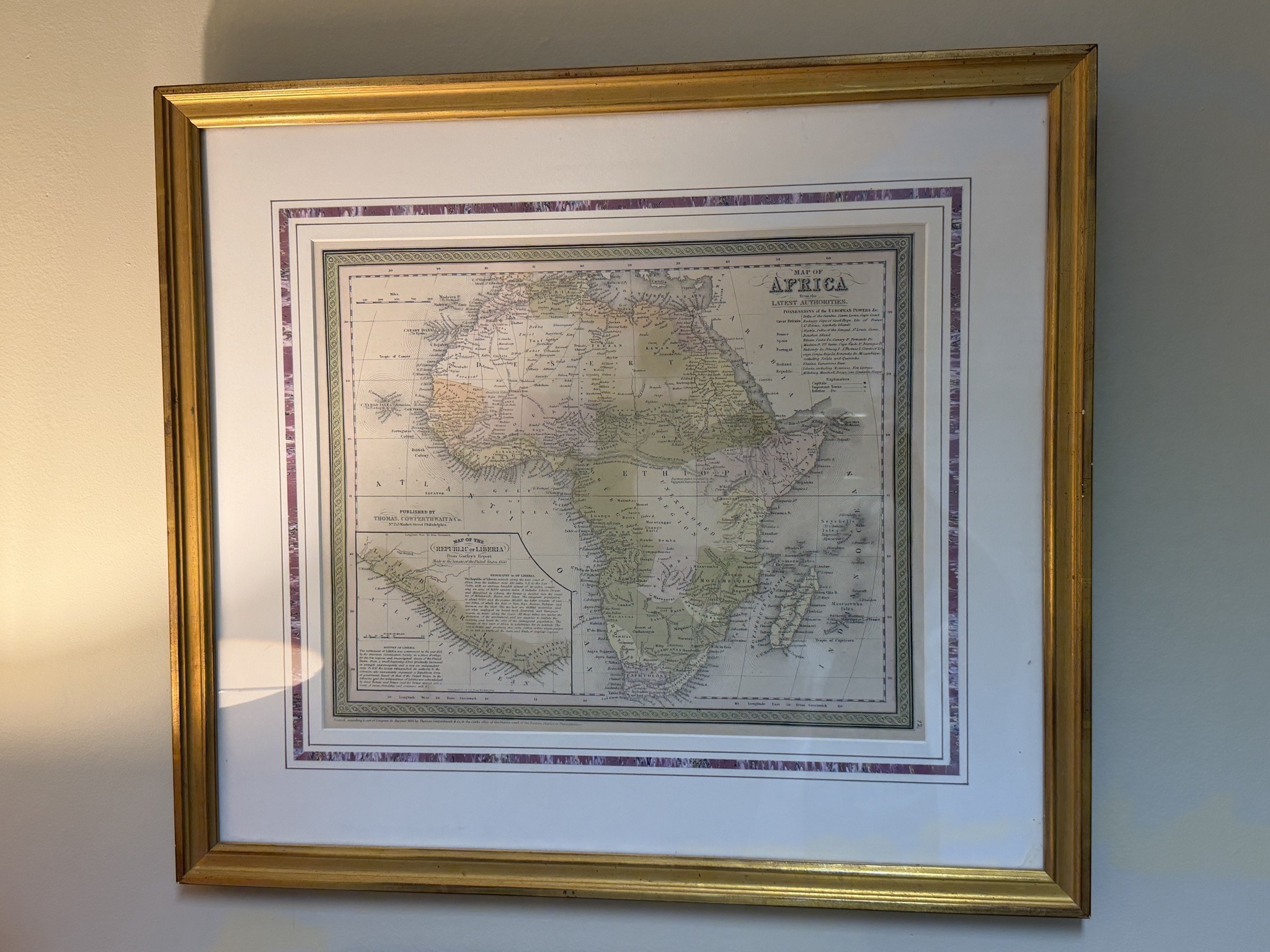
Map of Africa from the Latest Authorities by Thomas, Cowperthwait & Co.
This is a mid-19th-century hand-colored engraved map of Africa, titled 'Map of Africa from the Latest Authorities.' The map was published by Thomas, Cowperthwait & Co. at No. 253 Market Street, Philadelphia, likely around 1850-1853. It features an inset in the lower-left corner titled 'Map of the Republic of Liberia' with accompanying geographical text. The map utilizes a pastel color palette (pinks, yellows, and greens) for hand-shading different colonial possessions and territories. It is framed within a decorative rope-style border classic to the Mitchell school of cartography. The framing is elaborate, consisting of a gilded wood frame, a wide white mat, and an inner decorative marbled paper mat in purple and white. The condition appears sound; however, typical vertical and horizontal fold lines are visible from its original state in an atlas, along with some slight tanning or foxing consistent with age. Notable text includes a key of 'Possessions of the European Powers' indicating areas held by Great Britain, France, Spain, Portugal, and Holland. The map reflects a historical period of transition before the 'Scramble for Africa' accelerated, depicting many interior areas as 'unexplored' or marked with indigenous tribal names.
AI-Generated Appraisal Disclaimer
Estimated Value
$450-$650
Basic Information
Category
Antiques & Collectibles - Maps and Cartography
Appraised On
May 7, 2026
Estimated Value
$450-$650
Item Description
This is a mid-19th-century hand-colored engraved map of Africa, titled 'Map of Africa from the Latest Authorities.' The map was published by Thomas, Cowperthwait & Co. at No. 253 Market Street, Philadelphia, likely around 1850-1853. It features an inset in the lower-left corner titled 'Map of the Republic of Liberia' with accompanying geographical text. The map utilizes a pastel color palette (pinks, yellows, and greens) for hand-shading different colonial possessions and territories. It is framed within a decorative rope-style border classic to the Mitchell school of cartography. The framing is elaborate, consisting of a gilded wood frame, a wide white mat, and an inner decorative marbled paper mat in purple and white. The condition appears sound; however, typical vertical and horizontal fold lines are visible from its original state in an atlas, along with some slight tanning or foxing consistent with age. Notable text includes a key of 'Possessions of the European Powers' indicating areas held by Great Britain, France, Spain, Portugal, and Holland. The map reflects a historical period of transition before the 'Scramble for Africa' accelerated, depicting many interior areas as 'unexplored' or marked with indigenous tribal names.
Get Your Items Appraised
Instant estimates of your treasures with AI-powered instant appraisals