Appraisal
Historic Map Of Paris C 1600 Appraisal
Get AI-powered appraisal estimates for your Historic Map Of Paris C 1600. Upload a photo for instant valuation.
Recent historic map of paris c 1600 appraisals
Print/Map
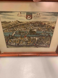
Historic Map/View of Paris (Lutetia) c. 1600
Antique Map/Cartography
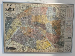
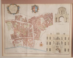
Framed Antique 'Plan de Paris' Map
Antique Cartography and Historical Prints
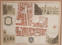
Stow's Survey of London: Cheap Ward Map
Antique Maps and Cartography
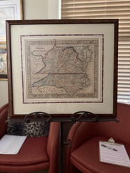
Samuel Augustus Mitchell 'County Map of Virginia and North Carolina' (c. 1860-1867)
Antique Map / Historical Print
Farringdon Ward Without, with its Division into Parishes according to a New Survey (Strype's Survey of London)

Antique Maps
Historical Map of the United States
Historical Map
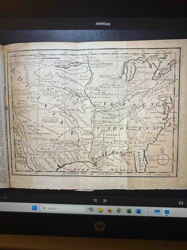
1763 Map of a Portion of North America from Gentlemen's Magazine

Framed Map / Art
Framed Map of Czechoslovakia (Stylized)
Decorative Art / Map Reproduction
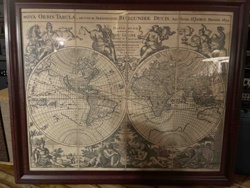
Nova Orbis Tabula World Map Reproduction (Authore H. Jaillot, Parisiis 1694)
Art & Collectibles
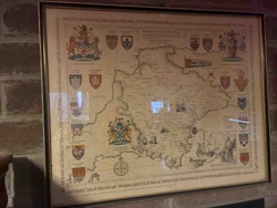
Framed Pictorial Map of County Durham
Print/Map
Historic Map/View of Paris (Lutetia) c. 1600
Antique Map/Cartography
Framed Antique 'Plan de Paris' Map
Antique Cartography and Historical Prints
Stow's Survey of London: Cheap Ward Map
Antique Maps and Cartography
Samuel Augustus Mitchell 'County Map of Virginia and North Carolina' (c. 1860-1867)
Antique Map / Historical Print
Farringdon Ward Without, with its Division into Parishes according to a New Survey (Strype's Survey of London)
Antique Maps
Historical Map of the United States
Historical Map
1763 Map of a Portion of North America from Gentlemen's Magazine
Framed Map / Art
Framed Map of Czechoslovakia (Stylized)
Decorative Art / Map Reproduction
Nova Orbis Tabula World Map Reproduction (Authore H. Jaillot, Parisiis 1694)
Art & Collectibles
Framed Pictorial Map of County Durham
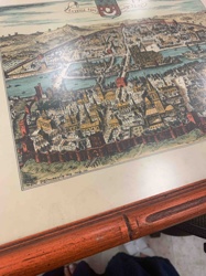
Framed Print/Map
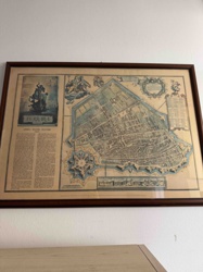
Framed 'Lutetia 1609' Cityscape Print (Paris)

Antique Cartography and Printed Maps
A New & Accurate Map of North America (c. 1790s)
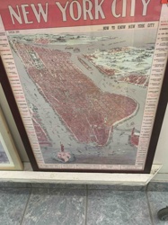
Map / Wall Art
New York City Circa 1899 "How to Know New York City" Framed Map
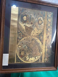
Decorative Arts / Cartographic Reproductions
Framed Gold Foil Reproduction of Willem Blaeu's 'Nova Totius Terrarum Orbis Geographica ac Hydrographica Tabula' World Map
Antique Maps and Cartography
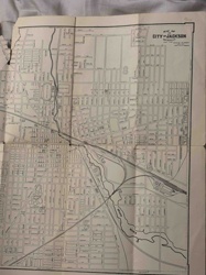
Vintage Map of the City of Jackson, Michigan
Antique Map
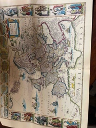
Antique Hand-Colored Map of Europa (Europe)
Antique Books and Manuscripts
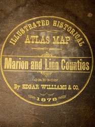
Illustrated Historical Atlas Map of Marion and Linn Counties, Oregon (1878)

Map
Vintage China Map
Antique Map
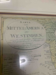
Karte von Mittel-America oder Westindien (Map of Central America or West Indies)
Antique Map
Framed Antique Map of Ferrara (Attributed to Blaeu or similar Dutch Cartographer)
Framed Print/Map
Framed 'Lutetia 1609' Cityscape Print (Paris)
Antique Cartography and Printed Maps
A New & Accurate Map of North America (c. 1790s)
Map / Wall Art
New York City Circa 1899 "How to Know New York City" Framed Map
Decorative Arts / Cartographic Reproductions
Framed Gold Foil Reproduction of Willem Blaeu's 'Nova Totius Terrarum Orbis Geographica ac Hydrographica Tabula' World Map
Antique Maps and Cartography
Vintage Map of the City of Jackson, Michigan
Antique Map
Antique Hand-Colored Map of Europa (Europe)
Antique Books and Manuscripts
Illustrated Historical Atlas Map of Marion and Linn Counties, Oregon (1878)
Map
Vintage China Map
Antique Map
Karte von Mittel-America oder Westindien (Map of Central America or West Indies)
Antique Map
Framed Antique Map of Ferrara (Attributed to Blaeu or similar Dutch Cartographer)
Process
How our AI historic map of paris c 1600 appraisal works
- 01
Upload your photo
Take a clear photo of your historic map of paris c 1600 and upload it. One photo is all you need.
- 02
AI analysis
Our advanced AI technology analyzes your item.
- 03
Receive estimate
Get a detailed appraisal report with estimated value range, market insights, and item details.
Get the best appraisal
For the best results
- Use good lighting to capture all details
- Place item on a neutral background
- Include any identifying marks or labels
- Ensure the entire item is visible in frame
Ready to appraise your historic map of paris c 1600?
Get your free AI-powered appraisal in under 60 seconds
No registration required · Free to use · Instant results