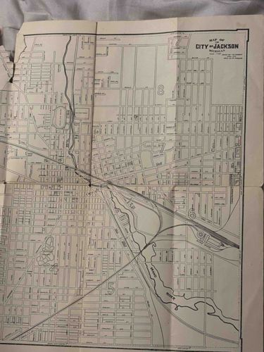
Vintage Map of the City of Jackson, Michigan
Antique Maps and Cartography

Vintage Map of the City of Jackson, Michigan

This is a vintage paper street map featuring the City of Jackson, Michigan, likely dating from the early to mid-20th century. The map is printed on a medium-weight paper stock that shows significant age-related toning, turning a cream or light tan color. It is a monochromatic print using black ink for the cartography, including street layouts, railway lines, and the winding path of the Grand River. The map is a fold-out style with visible vertical and horizontal crease lines from previous folding. A notable cartographic feature is the block-style numbering (e.g., '4', '5', '8') situated within different city districts. The title block in the upper right corner reads 'MAP OF THE CITY OF JACKSON, MICHIGAN' followed by attribution text. In terms of condition, the map shows significant wear: there are visible tears and losses along the left-hand margin, particularly near the top edge, and distressing along the central vertical folds. There is minor spotting and handling soil consistent with its age and use. The topographical detail is high for the period, showing specific rail hubs and park layouts, which suggests a professional engineering or municipal origin rather than a simple tourist handout. Such maps were common for business or city planning use during the expansion era of the Michigan automotive and rail industries.

Estimated Value

$100 - $175

Basic Information

Category

Antique Maps and Cartography

Appraised On

March 1, 2026

Estimated Value

$100 - $175

Item Description

This is a vintage paper street map featuring the City of Jackson, Michigan, likely dating from the early to mid-20th century. The map is printed on a medium-weight paper stock that shows significant age-related toning, turning a cream or light tan color. It is a monochromatic print using black ink for the cartography, including street layouts, railway lines, and the winding path of the Grand River. The map is a fold-out style with visible vertical and horizontal crease lines from previous folding. A notable cartographic feature is the block-style numbering (e.g., '4', '5', '8') situated within different city districts. The title block in the upper right corner reads 'MAP OF THE CITY OF JACKSON, MICHIGAN' followed by attribution text. In terms of condition, the map shows significant wear: there are visible tears and losses along the left-hand margin, particularly near the top edge, and distressing along the central vertical folds. There is minor spotting and handling soil consistent with its age and use. The topographical detail is high for the period, showing specific rail hubs and park layouts, which suggests a professional engineering or municipal origin rather than a simple tourist handout. Such maps were common for business or city planning use during the expansion era of the Michigan automotive and rail industries.

Get Your Items Appraised

Instant estimates of your treasures with AI-powered instant appraisals

Browse More Appraisals