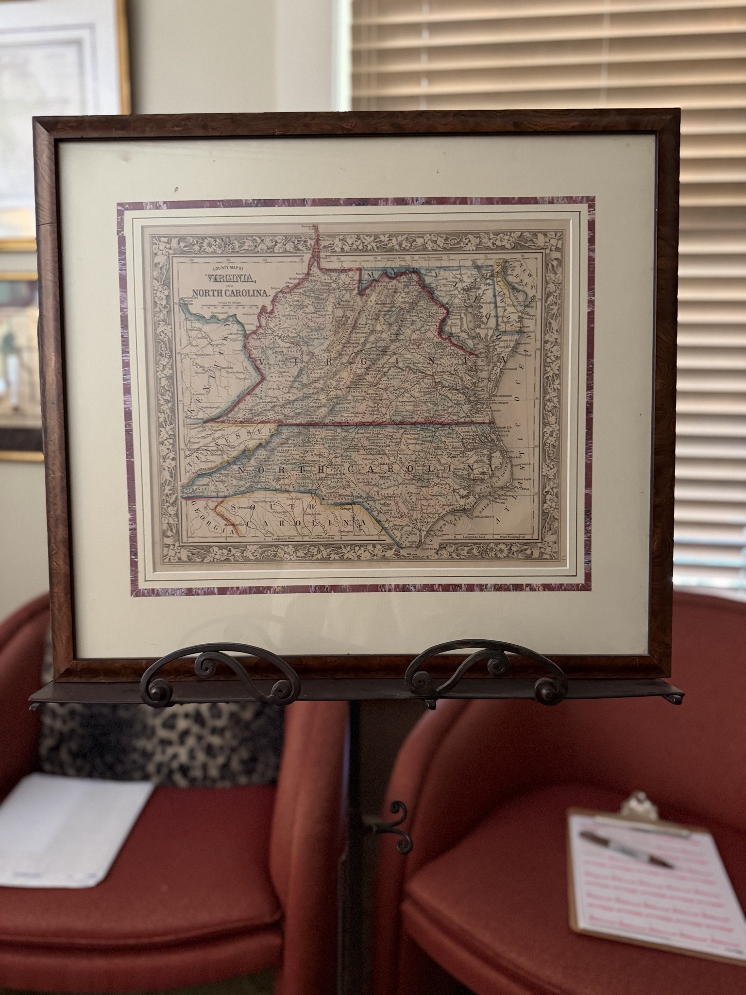
Samuel Augustus Mitchell 'County Map of Virginia and North Carolina' (c. 1860-1867)
Antique Maps and Cartography

Samuel Augustus Mitchell 'County Map of Virginia and North Carolina' (c. 1860-1867)

This is a framed, mid-19th-century hand-colored lithographic map titled 'County Map of Virginia and North Carolina.' The map features intricate detailing typical of Samuel Augustus Mitchell’s publications, including the signature floral vinework border. It illustrates the late Civil War or immediate post-war era geography, showing county lines, railroads, and topographical features. The border lines for Virginia and North Carolina are manually highlighted in red/pink ink. The paper appears to be an off-white wove paper, showing significant age-toning and a mellowed patina consistent with an original 1860s print. The piece is professionally presented in a double-matted frame, with a decorative marbled inner mat and an outer cream mat. It is encased in a polished wood frame with a burl-wood finish. Notable features include the detailed 'Scale of Miles' and longitudinal markings from both Washington and Greenwich. While the map itself seems to be in good condition, there is slight rippling detectable, suggesting it is not laid flat, and minor foxing or oxidation may be present upon close physical inspection. This specific style of cartography is highly collected for its aesthetic appeal and historical accuracy regarding 19th-century American expansion and rail infrastructure.

Estimated Value

$350.00 - $550.00

Basic Information

Category

Antique Maps and Cartography

Appraised On

May 7, 2026

Estimated Value

$350.00 - $550.00

Item Description

This is a framed, mid-19th-century hand-colored lithographic map titled 'County Map of Virginia and North Carolina.' The map features intricate detailing typical of Samuel Augustus Mitchell’s publications, including the signature floral vinework border. It illustrates the late Civil War or immediate post-war era geography, showing county lines, railroads, and topographical features. The border lines for Virginia and North Carolina are manually highlighted in red/pink ink. The paper appears to be an off-white wove paper, showing significant age-toning and a mellowed patina consistent with an original 1860s print. The piece is professionally presented in a double-matted frame, with a decorative marbled inner mat and an outer cream mat. It is encased in a polished wood frame with a burl-wood finish. Notable features include the detailed 'Scale of Miles' and longitudinal markings from both Washington and Greenwich. While the map itself seems to be in good condition, there is slight rippling detectable, suggesting it is not laid flat, and minor foxing or oxidation may be present upon close physical inspection. This specific style of cartography is highly collected for its aesthetic appeal and historical accuracy regarding 19th-century American expansion and rail infrastructure.

Get Your Items Appraised

Instant estimates of your treasures with AI-powered instant appraisals

Browse More Appraisals