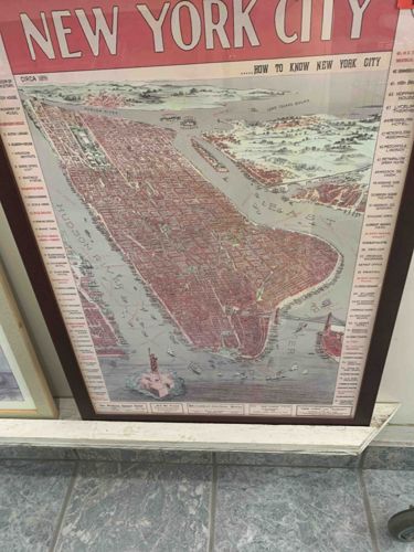
New York City Circa 1899 "How to Know New York City" Framed Map
Map / Wall Art

New York City Circa 1899 "How to Know New York City" Framed Map

The item is a framed historical map of New York City, likely a reproduction or original print, titled "NEW YORK CITY" at the top, followed by "... HOW TO KNOW NEW YORK CITY." The map itself depicts Manhattan and surrounding boroughs and waterways, prominently featuring the Hudson River to the west and what appears to be the East River to the east. The landmasses, particularly Manhattan, are depicted in a reddish-brown hue, indicating built-up areas or city blocks, contrasting with the light blue-grey of the water. Small details like boats are visible in the water, and the Statue of Liberty is clearly depicted in the harbor area. The overall style suggests an isometric or bird's-eye view rather than a standard flat projection, giving a three-dimensional impression of the city. The top left corner of the map includes text "CIRCA 1899," indicating its estimated age or the period it represents. Along the left and right margins of the map, there are numbered lists of points of interest, further adding to its informative nature. The map is housed within a dark brown wooden frame, which shows some visible wear and tear, including scuffs and possibly some chipping, particularly visible at the bottom left corner where the frame meets the white molding. The paper or print material of the map itself appears to have some discoloration or foxing, consistent with age or exposure, and some creasing or rippling may be present, though difficult to ascertain definitively from the image. The colors, while somewhat muted, retain a vintage appeal. There are no readily discernible manufacturer's marks or specific artist signatures visible in the provided image.

Estimated Value

$75-125

Basic Information

Category

Map / Wall Art

Appraised On

August 28, 2025

Estimated Value

$75-125

Item Description

The item is a framed historical map of New York City, likely a reproduction or original print, titled "NEW YORK CITY" at the top, followed by "... HOW TO KNOW NEW YORK CITY." The map itself depicts Manhattan and surrounding boroughs and waterways, prominently featuring the Hudson River to the west and what appears to be the East River to the east. The landmasses, particularly Manhattan, are depicted in a reddish-brown hue, indicating built-up areas or city blocks, contrasting with the light blue-grey of the water. Small details like boats are visible in the water, and the Statue of Liberty is clearly depicted in the harbor area. The overall style suggests an isometric or bird's-eye view rather than a standard flat projection, giving a three-dimensional impression of the city. The top left corner of the map includes text "CIRCA 1899," indicating its estimated age or the period it represents. Along the left and right margins of the map, there are numbered lists of points of interest, further adding to its informative nature. The map is housed within a dark brown wooden frame, which shows some visible wear and tear, including scuffs and possibly some chipping, particularly visible at the bottom left corner where the frame meets the white molding. The paper or print material of the map itself appears to have some discoloration or foxing, consistent with age or exposure, and some creasing or rippling may be present, though difficult to ascertain definitively from the image. The colors, while somewhat muted, retain a vintage appeal. There are no readily discernible manufacturer's marks or specific artist signatures visible in the provided image.

Get Your Items Appraised

Instant estimates of your treasures with AI-powered instant appraisals