AI estimate as of December 14, 2025 · verify with a professional before acting
AI-Generated · Verify before acting
Everything on this page is generated by AI for informational purposes only. AI can make mistakes — the AI may misidentify items or misattribute them (artist, maker, brand, designer, origin, era). This is not an official valuation and should not be used for insurance, sale, tax, estate, legal, or lending purposes — or any decision requiring a certified appraisal. It is not an authoritative claim about any person, brand, or rights holder — do not share or rely on it as a factual statement about a third party. Always consult qualified professionals before making financial decisions.
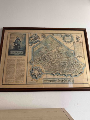
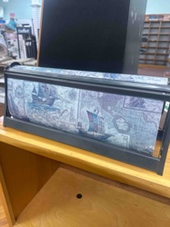
This item is a framed antique city plan or map of 'FERRARI. FORMAE URBIS DELINEATIO', which translates to 'Ferrara. Outline of the City Form'. The map depicts a detailed birds-eye view of the city of Ferrara, Italy, characterized by its star-shaped fortifications, intricate street layout, and individual buildings. The primary colors that dominate the map are muted blues, light brown/beige, and sepia tones for the text and details. The map itself appears to be printed on paper, showing signs of age-related toning and potential foxing, consistent with antique paper.
Notable features include several decorative cartouches and borders. In the upper left, there's a prominent depiction of a figure on horseback, possibly a ruler or noble, above the map's title. Below this, a large block of text provides descriptive information about Ferrara, likely in Latin. The upper right corner features an ornate, possibly allegorical, scene with winged figures, and another decorative cartouche enclosing what might be a dedication or further descriptive text. Below the main map, there's a smaller inset drawing depicting a cityscape or architectural feature, possibly a panoramic view.
Several quality indicators suggest this is a fine example of early modern cartography. The detailed engraving, the artistic embellishments, and the clear topographical representation are hallmarks of high-quality maps from the 17th or 18th centuries, often associated with renowned Dutch cartographers like Joan Blaeu or the Janssonius family. The item is housed in a simple, dark brown wooden frame, possibly a modern addition, which protects the map behind a glass or acrylic front. The condition of the map appears good for its age, though the exact extent of preservation or any repairs is not fully discernible through the image. The toning of the paper indicates natural aging and sun exposure over centuries. The frame itself shows minimal wear, appearing to be in good condition.
AI Appraisal Report
Based on my visual examination of the provided image, this framed antique map of Ferrara, 'FERRARI. FORMAE URBIS DELINEATIO', presents as a high-quality example of early modern cartography. The detailed engraving, artistic embellishments including the figure on horseback and allegorical upper-right scene, and clear topographical representation align with the characteristics of renowned 17th or 18th-century Dutch cartographers such as Blaeu or Janssonius. The paper exhibits natural toning and potential foxing, consistent with centuries of age, which contributes to its authenticity and aesthetic appeal. The dark brown wooden frame appears to be a sympathetic, likely modern, addition, and is in good condition.
From the image, the map's condition appears good for its age. The primary challenge in authentication without physical inspection lies in verifying the precise cartographer, paper quality, printing process, and ruling out later reproductions or facsimiles. An in-person inspection would allow for examination of plate marks, paper texture, watermarks, and printing methods. Provenance documentation, if available, would provide crucial historical context and ownership lineage. Scientific testing, such as paper analysis, could further confirm age and composition.
Market conditions for detailed, well-preserved city plans from this era are generally strong, particularly for recognizable European cities. Maps attributed to major Dutch cartographers command higher values. The high level of detail and decorative elements increase demand and rarity. Comparables for similar high-quality city plans by Blaeu or Janssonius typically fall within the higher end of this range, or even exceed it depending on condition and specific edition. The current frame protects the map, but its non-originality does not detract significantly from the map's inherent value. Given these factors and the clear visual quality, I assess a value range of $1,800-2,500 for this piece.