AI estimate as of August 7, 2025 · verify with a professional before acting
AI-Generated · Verify before acting
Everything on this page is generated by AI for informational purposes only. AI can make mistakes — the AI may misidentify items or misattribute them (artist, maker, brand, designer, origin, era). This is not an official valuation and should not be used for insurance, sale, tax, estate, legal, or lending purposes — or any decision requiring a certified appraisal. It is not an authoritative claim about any person, brand, or rights holder — do not share or rely on it as a factual statement about a third party. Always consult qualified professionals before making financial decisions.
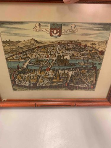
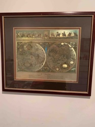
The item is a framed print, likely a map or an elevated view (bird's-eye view) of an ancient city, specifically identified by the text at the top as 'LVETIA 1600' and 'vulgò PARIS', suggesting it depicts Paris around the year 1600. The print appears to be a hand-colored engraving or lithograph, characterized by vibrant, albeit somewhat faded, colors that accent buildings, rivers, and landscape features. The primary colors visible are shades of green for land, blue for water, and various earth tones and reds for structures.
The composition shows the city stretching across a wide area, with a prominent river (likely the Seine) winding through it, crossed by multiple bridges. Detailed architectural elements are visible, including numerous churches, cathedrals (one likely being Notre Dame given its prominent central position and twin towers), and dense urban housing. Surrounding the city, there are visual representations of hills or fortifications.
Two notable features at the top of the print are a decorative banner containing the aforementioned text and what appears to be an armorial crest or coat of arms, possibly of the city or a ruling entity, positioned centrally above the city view. The overall aesthetic suggests a historic cartographic or illustrative style, indicative of the 16th or 17th century.
The print is housed within a wooden frame that exhibits a reddish-brown hue and a 'bamboo' or reeded, possibly carved, design. The frame shows signs of wear and tear, including a noticeable crack or separation in the wood on the bottom central part, suggesting potential damage or repair. The print itself seems generally well-preserved within the frame, though the extent of any foxing, discoloration, or paper damage is not fully discernible due to the image quality and framing. There are no visible manufacturer's marks or signatures on the print itself from the provided images, which could be obscured by the matting or frame. The quality of the printing appears fine, with good detail for the period it represents. The item's age aligns with the depicted year, making it a historical piece.
AI Appraisal Report
Based on my visual examination of the images provided, this item appears to be a hand-colored engraved or lithographic print depicting a bird's-eye view of Paris, titled 'Lutetia', around the year 1600. The print's style is consistent with 17th-century cartography, possibly a later state or reproduction of a famous map, such as a Braun & Hogenberg or a similar contemporary work. The hand-coloring seems appropriate for the period, though its age cannot be confirmed without physical inspection. The condition appears fair, with vibrant colors, but there are signs of potential fading. The frame, while aesthetically pleasing with its reeded bamboo-style design, shows visible wear, including a significant crack on the bottom rail, which detracts slightly from the overall presentation.
The primary factor impacting value is its authenticity. If this is a genuine 17th-century printing, its value would be considerably higher. However, it is common for such historic maps to be reproduced in later centuries. Demand for early Parisian maps is consistently strong among collectors. Comparable, authenticated 17th-century Paris maps from atlases like Braun & Hogenberg's 'Civitates orbis terrarum' regularly sell for $1,500 to $4,000, depending on condition and coloring. High-quality 19th-century reproductions can fetch $200-$500.
Critically, I cannot authenticate this piece from images alone. A full appraisal requires physical examination to assess the paper type, watermark, plate marks, and signs of modern printing techniques. Provenance documentation would be invaluable. Without this verification, the valuation must remain conservative, accounting for the possibility of it being a later reproduction.