Appraisal
Essex Cartography Appraisal
Get AI-powered appraisal estimates for your Essex Cartography. Upload a photo for instant valuation.
Recent essex cartography appraisals

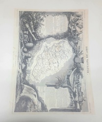
Antique Cartography and Fine Art Prints
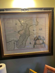
Antique Engraved Map of the Province of Essex
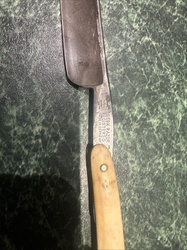
Personal Care Tools and Accessories
Essex Razor-marked straight razor with cream-colored handle
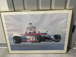
Art Print
Vintage Formula 1 'Essex' Racing Car Art Print

Prints and Maps
Vintage city map of Florence (Firenze), Italy
Antique Cartography and Art Prints
Victor Levasseur's Cartographic Engraving of the Département de Vaucluse
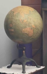
Antiques & Collectibles / Cartography
Vintage Desktop Globe with Cast Iron Tripod Base
Antique Maps and Cartography
Framed Hand-Colored Map of Calabria Citra by Willem Blaeu
Prints and Maps
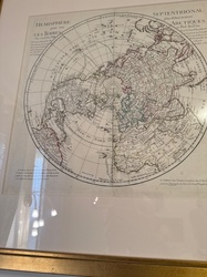
Reproduction-style polar projection world map bearing Guillaume Delisle and Philippe Buache markings

Antique Cartography and Printed Maps
A New & Accurate Map of North America (c. 1790s)
Antique Prints and Maps
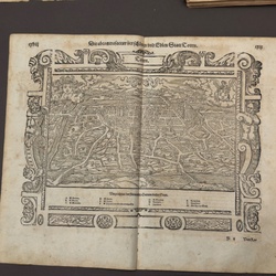
Woodcut topographical map of Tours in the style of Sebastian Münster
Antique Cartography and Fine Art Prints
Antique Engraved Map of the Province of Essex
Personal Care Tools and Accessories
Essex Razor-marked straight razor with cream-colored handle
Art Print
Vintage Formula 1 'Essex' Racing Car Art Print
Prints and Maps
Vintage city map of Florence (Firenze), Italy
Antique Cartography and Art Prints
Victor Levasseur's Cartographic Engraving of the Département de Vaucluse
Antiques & Collectibles / Cartography
Vintage Desktop Globe with Cast Iron Tripod Base
Antique Maps and Cartography
Framed Hand-Colored Map of Calabria Citra by Willem Blaeu
Prints and Maps
Reproduction-style polar projection world map bearing Guillaume Delisle and Philippe Buache markings
Antique Cartography and Printed Maps
A New & Accurate Map of North America (c. 1790s)
Antique Prints and Maps
Woodcut topographical map of Tours in the style of Sebastian Münster
Military Memorabilia / Naval Artifacts
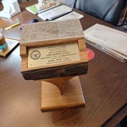
Commemorative USS Essex (CV-9) Deck Planking Presentation Piece
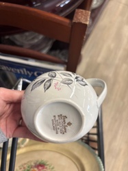
Antique & Vintage English Ceramics
Crown Essex Semi-Porcelain Tea Cup with Floral Transfers
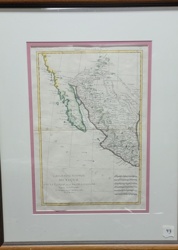
Antique Cartography and Maps
L'Ancien et le Nouveau Mexique (Ancient and New Mexico) Map by Rigobert Bonne
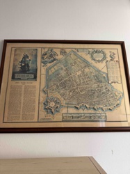
Antique Map
Framed Antique Map of Ferrara (Attributed to Blaeu or similar Dutch Cartographer)

Antique Maps and Prints
Victor Levasseur's Cartographic Engraving of the Departement de la Gironde

Antique Maps and Prints
Antique Illustrated Lithograph Map of the Department of Tarn, France

Maps and Cartography
Vintage World Map
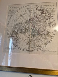
Historical Maps and Prints
Framed circular map of the Northern Hemisphere in the 18th-century French style

Antique Cartography and Prints
Victor Levasseur 'Atlas National Illustré' Map of the Department of Aude, France

Antique Maps and Cartography
Provincia di Surrey: di Nuova Projezione, Venice, 1779
Military Memorabilia / Naval Artifacts
Commemorative USS Essex (CV-9) Deck Planking Presentation Piece
Antique & Vintage English Ceramics
Crown Essex Semi-Porcelain Tea Cup with Floral Transfers
Antique Cartography and Maps
L'Ancien et le Nouveau Mexique (Ancient and New Mexico) Map by Rigobert Bonne
Antique Map
Framed Antique Map of Ferrara (Attributed to Blaeu or similar Dutch Cartographer)
Antique Maps and Prints
Victor Levasseur's Cartographic Engraving of the Departement de la Gironde
Antique Maps and Prints
Antique Illustrated Lithograph Map of the Department of Tarn, France
Maps and Cartography
Vintage World Map
Historical Maps and Prints
Framed circular map of the Northern Hemisphere in the 18th-century French style
Antique Cartography and Prints
Victor Levasseur 'Atlas National Illustré' Map of the Department of Aude, France
Antique Maps and Cartography
Provincia di Surrey: di Nuova Projezione, Venice, 1779
Process
How our AI essex cartography appraisal works
- 01
Upload your photo
Take a clear photo of your essex cartography and upload it. One photo is all you need.
- 02
AI analysis
Our advanced AI technology analyzes your item.
- 03
Receive estimate
Get a detailed appraisal report with estimated value range, market insights, and item details.
Get the best appraisal
For the best results
- Use good lighting to capture all details
- Place item on a neutral background
- Include any identifying marks or labels
- Ensure the entire item is visible in frame
Ready to appraise your essex cartography?
Get your free AI-powered appraisal in under 60 seconds
No registration required · Free to use · Instant results