AI Appraisal Estimate

AI-generated estimates · not official valuations

From the user

What was submitted

Photo and notes provided by the user — not generated by AI

Submitted item photo
Submitted photo · June 18, 2026

User's notes

No additional notes provided.

AI analysis below

AI appraisal

AI analysis & estimate

AI-Generated · Verify before acting

Everything below is generated by AI for informational purposes only. AI can make mistakes — the AI may misidentify items or misattribute them (artist, maker, brand, designer, origin, era). This is not an official valuation and should not be used for insurance, sale, tax, estate, legal, or lending purposes — or any decision requiring a certified appraisal. It is not an authoritative claim about any person, brand, or rights holder — do not share or rely on it as a factual statement about a third party. Always consult qualified professionals before making financial decisions.

Read the full disclaimer

AI Identification

·Not independently authenticated·Verify before acting

Reproduction-style polar projection world map bearing Guillaume Delisle and Philippe Buache markings

Prints and Maps

AI Estimated Value

·Not an official valuation·Verify before acting

$50 - $150

As of June 18, 2026

AI Item Analysis

·AI can make mistakes·Verify before acting
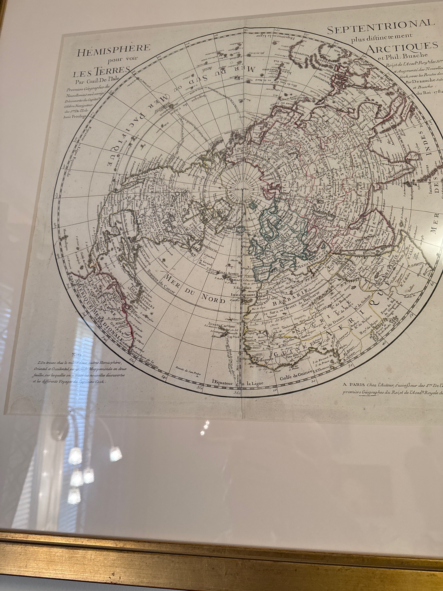
This item is a framed map featuring a polar projection titled 'HEMISPHERE pour voir LES TERRES Par Guil De L'Isle'. The work is printed on paper with a slightly off-white or cream tone and contains intricate black linework with subtle watercolor-style tinting in shades of green, red, and yellow outlining various geographical regions. It includes elaborate French text, notably attributing the original cartography to Guillaume Delisle and mentioning Phlippe Buache, with a published date marked as 1782 'A PARIS Chez l'Auteur'. The map displays the Northern Hemisphere with a focus on 'ARCTIQUES' and includes detailed nautical routes, including mentions of Captain Cook's voyages in the 'Nota' section. While the map bears markings consistent with an 18th-century French engraving, without physical inspection of the paper's watermark, the plate marks, and the printing method (intaglio vs. offset lithography), it is considered a reproduction or a style-consistent print. The condition appears excellent with no visible foxing, tearing, or significant fading, though it is viewed through glazing which may obscure fine details. The framing consists of a white mat and a thin gold-toned metallic or wood frame.

AI Appraisal Report

·AI can make mistakes·Verify before acting
Based on the provided image, I have evaluated this framed polar projection map bearing markings attributing the original cartography to Guillaume Delisle and mentioning Philippe Buache, with a published date of 1782. From a photograph alone, I cannot examine the paper's watermark, plate marks, or the printing method to determine its exact age or production technique. The piece displays intricate black linework with watercolor-style tinting and detailed French text. The condition appears to be visually excellent without obvious foxing or tearing, though it is viewed through glazing which may obscure fine details. The framing includes a white mat and a thin gold-toned frame. For the purposes of this appraisal, I am treating the item as a decorative reproduction or style-consistent print, as is common with maps presenting these specific 18th-century markings without signs of period aging or verifiable intaglio marks. The estimated appraisal value of $50 to $150 reflects the decorative appeal of the print and the cost of the framing. If an in-person examination by a map specialist or paper conservator were to indicate it is a period 18th-century engraving, the market value would be substantially higher. However, as it currently stands as an assumed reproduction, the market demand is driven primarily by interior decoration rather than antiquarian collectibility.

Get your items appraised

Instant estimates of your treasures with AI-powered appraisals

Browse More Appraisals