Appraisal
19th Century Map Engraving Appraisal
Get AI-powered appraisal estimates for your 19th Century Map Engraving. Upload a photo for instant valuation.
Recent 19th century map engraving appraisals

Antique Cartography and Art Prints
Victor Levasseur's Cartographic Engraving of the Département de Vaucluse
Art - Antique Prints and Engravings
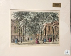
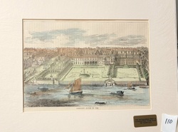
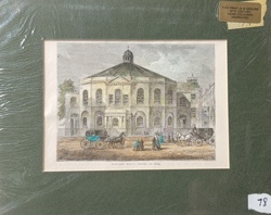
Marylebone Gardens, London (Antique Engraving)
Print/Engraving
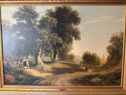
Framed 18th/19th Century British Landscape Engraving/Print
Framed Artwork
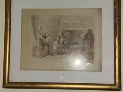
Framed 19th Century Domestic Scene Engraving/Print
Art Print / Engraving
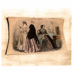
Antiquarian Engraving of 19th-Century Women's Fashion
Antiques & Collectibles - Cartography
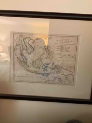
Framed 19th Century Map of the East Indies with the Channels between India, China & New Holland

Antique Cartography and Paper Ephemera
Antiquarian Map: Russie d'Europe, 1850

Antique Maps and Prints
Victor Levasseur's Cartographic Engraving of the Departement de la Gironde

Antique Maps and Prints
Victor Levasseur Antique Map of the Tarn-et-Garonne Department
Antique Cartography & Prints
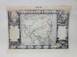
Levasseur Antique Map of Asia (Asie) from the 'Atlas National Illustre'
Antique Cartography and Art Prints
Victor Levasseur's Cartographic Engraving of the Département de Vaucluse
Art - Antique Prints and Engravings
Marylebone Gardens, London (Antique Engraving)
Print/Engraving
Framed 18th/19th Century British Landscape Engraving/Print
Framed Artwork
Framed 19th Century Domestic Scene Engraving/Print
Art Print / Engraving
Antiquarian Engraving of 19th-Century Women's Fashion
Antiques & Collectibles - Cartography
Framed 19th Century Map of the East Indies with the Channels between India, China & New Holland
Antique Cartography and Paper Ephemera
Antiquarian Map: Russie d'Europe, 1850
Antique Maps and Prints
Victor Levasseur's Cartographic Engraving of the Departement de la Gironde
Antique Maps and Prints
Victor Levasseur Antique Map of the Tarn-et-Garonne Department
Antique Cartography & Prints
Levasseur Antique Map of Asia (Asie) from the 'Atlas National Illustre'
Antique Maps and Cartography
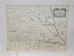
Antique Copperplate Engraved Map of Central Asia - Tabula VII Asiae
Antique Prints and Artworks
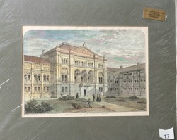
The Court of the South Kensington Museum - 19th Century Hand-Coloured Engraving
Antique Art & Prints
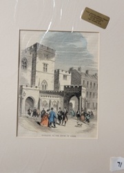
Entrance to the House of Lords - 19th Century Antiquarian Steel Engraving

Fine Art / Antiques
19th Century Steel Engraving of Windsor Castle
Antique Prints and Works on Paper
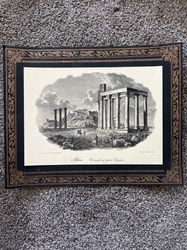
"Athens: The Temple of Jupiter Olympias" 19th-Century Copperplate Engraving
Antique Prints and Map Works
Somerset House in 1550 Engraving

Antique Maps and Prints
Victor Levasseur Map of the Département de Vaucluse
Antiquarian Prints and Art
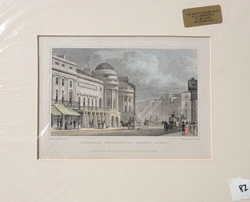
Harmonic Institution, Regent Street (Antiquarian Steel Engraving)
Antique Prints and Artworks
Rowland Hill's Chapel in 1814 Hand-Coloured Engraving
Antique Maps and Cartography
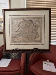
Samuel Augustus Mitchell 'County Map of Virginia and North Carolina' (c. 1860-1867)
Antique Maps and Cartography
Antique Copperplate Engraved Map of Central Asia - Tabula VII Asiae
Antique Prints and Artworks
The Court of the South Kensington Museum - 19th Century Hand-Coloured Engraving
Antique Art & Prints
Entrance to the House of Lords - 19th Century Antiquarian Steel Engraving
Fine Art / Antiques
19th Century Steel Engraving of Windsor Castle
Antique Prints and Works on Paper
"Athens: The Temple of Jupiter Olympias" 19th-Century Copperplate Engraving
Antique Prints and Map Works
Somerset House in 1550 Engraving
Antique Maps and Prints
Victor Levasseur Map of the Département de Vaucluse
Antiquarian Prints and Art
Harmonic Institution, Regent Street (Antiquarian Steel Engraving)
Antique Prints and Artworks
Rowland Hill's Chapel in 1814 Hand-Coloured Engraving
Antique Maps and Cartography
Samuel Augustus Mitchell 'County Map of Virginia and North Carolina' (c. 1860-1867)
Process
How our AI 19th century map engraving appraisal works
- 01
Upload your photo
Take a clear photo of your 19th century map engraving and upload it. One photo is all you need.
- 02
AI analysis
Our advanced AI technology analyzes your item.
- 03
Receive estimate
Get a detailed appraisal report with estimated value range, market insights, and item details.
Get the best appraisal
For the best results
- Use good lighting to capture all details
- Place item on a neutral background
- Include any identifying marks or labels
- Ensure the entire item is visible in frame
Ready to appraise your 19th century map engraving?
Get your free AI-powered appraisal in under 60 seconds
No registration required · Free to use · Instant results