AI Appraisal Estimate

AI-generated estimates · not official valuations

From the user

What was submitted

Photo and notes provided by the user — not generated by AI

Submitted item photo
Submitted photo · June 13, 2026

User's notes

No additional notes provided.

AI analysis below

AI appraisal

AI analysis & estimate

AI-Generated · Verify before acting

Everything below is generated by AI for informational purposes only. AI can make mistakes — the AI may misidentify items or misattribute them (artist, maker, brand, designer, origin, era). This is not an official valuation and should not be used for insurance, sale, tax, estate, legal, or lending purposes — or any decision requiring a certified appraisal. It is not an authoritative claim about any person, brand, or rights holder — do not share or rely on it as a factual statement about a third party. Always consult qualified professionals before making financial decisions.

Read the full disclaimer

AI Identification

·Not independently authenticated·Verify before acting

Antique Copperplate Engraved Map of Central Asia - Tabula VII Asiae

Antique Maps and Cartography

AI Estimated Value

·Not an official valuation·Verify before acting

$450 - $650

As of June 13, 2026

AI Item Analysis

·AI can make mistakes·Verify before acting
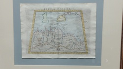
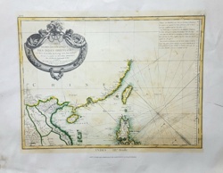
This is an original copperplate engraving of a classical map titled 'Tabula VII Asiae,' which depicts parts of Central Asia including Scythia, Sogdiana, Bactria, and Hyrcania. The map is based on Ptolemaic geography, showing the Caspian Sea (Hyrcanum et Caspium) and various mountain ranges of the region. It features a decorative rococo-style title cartouche in the upper right corner with intricate scrolls and acanthus leaf motifs. The engraving shows fine line work denoting river systems, topographical features represented by stylized 'molehill' mountains, and numerous Latin place names. The map is bordered by a graduated latitude and longitude scale. Physical characteristics include a heavy-weight laid paper with visible chain lines. The condition is fair to good for its age, showing significant water staining or foxing along the lower left corner and light creasing on the right margin. The ink remains dark and crisp, indicating a strong impression. This style of map typically dates from the late 16th to early 18th century, likely from an edition of Geographia or a similar classical atlas. Quality indicators include the sharp execution of the Latin typography and the detailed ornamentation of the cartouche, suggesting a skilled engraver of the period.

AI Appraisal Report

·AI can make mistakes·Verify before acting
I have virtually examined this copperplate engraving, identified as 'Tabula VII Asiae,' a map based on Claudius Ptolemy’s classical geography. The piece demonstrates hallmarks of 17th-century cartographic production, likely from a Mercator-Hondius or Magini edition of 'Geographia.' The dark, crisp ink impression and visible plate marks suggest an early strike from the copperplate, and the laid paper with distinct chain lines is consistent with period-appropriate rag paper. The map's aesthetic value is bolstered by the Rococo-style cartouche and detailed topographical renderings. However, the condition is a significant factor in this valuation. The visible water staining and foxing in the lower left quadrant, along with marginal creasing, necessitate professional restoration to reach the higher end of the market value. Comparable sales for Ptolemaic regional maps of Central Asia in pristine condition typically range from $800 to $1,200; the current estimate reflects a discount for the required conservation work. Market demand for Central Asian cartography remains steady among collectors of 'Silk Road' history. However, authentication based on digital images has inherent limitations. I cannot verify the watermark to pinpoint the exact paper mill or edition, nor can I test for acidity levels or identify modern photomechanical reproductions that mimic engraving. A physical inspection is required to confirm the 'bite' of the plate into the paper and ensure the staining hasn't caused structural fiber degradation. For a definitive authentication, I would recommend a light-table examination of the watermark and provenance documentation tracing the map to a specific atlas volume.

Get your items appraised

Instant estimates of your treasures with AI-powered appraisals

Browse More Appraisals