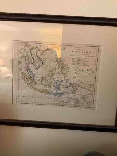
Framed 19th Century Map of the East Indies with the Channels between India, China & New Holland
Antiques & Collectibles - Cartography

Framed 19th Century Map of the East Indies with the Channels between India, China & New Holland

This item is a framed, hand-colored antique map titled ‘The Islands of the East Indies with the Channels between India, China & New Holland.’ The map depicts the Southeast Asian archipelago, including Java, Sumatra, Borneo, and the northern tip of Australia. It features delicate pastel watercolor outlines in shades of yellow, green, and blue to distinguish various colonial territories or geographical regions. The typography is characteristic of early-to-mid 19th-century copperplate engraving, with a clean title block and various legends to the right side detailing territorial ownership (British, Spanish, Dutch, Portuguese). The map is printed on aged paper that shows a slight warm tone consistent with antique documents. It is professionally matted with a thick, neutral-toned acid-free mat and housed in a dark wood or mahogany-finish frame with a beaded inner edge. There are no immediate visible signs of foxing, tearing, or moisture damage from the front, though there is a prominent vertical reflection on the protective glass. The overall craftsmanship suggests a high-quality decorative piece, likely intended for a historical or maritime-themed collection. The cartographic style and geographic labels suggest an origin around 1830 to 1850, a period of significant British and Dutch colonial expansion in the region.

Estimated Value

$450.00-$650.00

Basic Information

Category

Antiques & Collectibles - Cartography

Appraised On

March 3, 2026

Estimated Value

$450.00-$650.00

Item Description

This item is a framed, hand-colored antique map titled ‘The Islands of the East Indies with the Channels between India, China & New Holland.’ The map depicts the Southeast Asian archipelago, including Java, Sumatra, Borneo, and the northern tip of Australia. It features delicate pastel watercolor outlines in shades of yellow, green, and blue to distinguish various colonial territories or geographical regions. The typography is characteristic of early-to-mid 19th-century copperplate engraving, with a clean title block and various legends to the right side detailing territorial ownership (British, Spanish, Dutch, Portuguese). The map is printed on aged paper that shows a slight warm tone consistent with antique documents. It is professionally matted with a thick, neutral-toned acid-free mat and housed in a dark wood or mahogany-finish frame with a beaded inner edge. There are no immediate visible signs of foxing, tearing, or moisture damage from the front, though there is a prominent vertical reflection on the protective glass. The overall craftsmanship suggests a high-quality decorative piece, likely intended for a historical or maritime-themed collection. The cartographic style and geographic labels suggest an origin around 1830 to 1850, a period of significant British and Dutch colonial expansion in the region.

Get Your Items Appraised

Instant estimates of your treasures with AI-powered instant appraisals

Browse More Appraisals