Appraisal
Farringdon Ward Map Appraisal
Get AI-powered appraisal estimates for your Farringdon Ward Map. Upload a photo for instant valuation.
Recent farringdon ward map appraisals
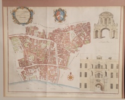
Antique Map / Historical Print
Farringdon Ward Without, with its Division into Parishes according to a New Survey (Strype's Survey of London)
Antique Cartography and Historical Prints
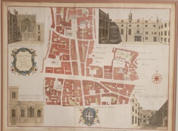
Stow's Survey of London: Cheap Ward Map
Antique Maps and Cartography
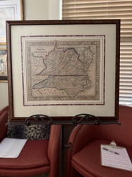
Samuel Augustus Mitchell 'County Map of Virginia and North Carolina' (c. 1860-1867)
Action Figure
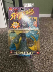
Spider-Man Spider-Wars Hydro-Man Aquatic Arsenal Action Figure

Military Decoration
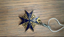
Pour le Mérite (Blue Max) Medal
Commemorative Drinkware
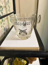
Vintage 'War Between the States' Tumbler Glass with General Jeb Stuart & Le Mat Pistols

Military Medal/Order
Pour le Mérite (Blue Max) Medal

Military Decoration/Medal
Pour le Mérite (Blue Max) Medal Replica or Variant
Military Decoration
Prussian Pour le Mérite Order (The Blue Max)

Military Decoration/Medal
Pour le Mérite (Blue Max) Military Order
Antique Map / Historical Print
Farringdon Ward Without, with its Division into Parishes according to a New Survey (Strype's Survey of London)
Antique Cartography and Historical Prints
Stow's Survey of London: Cheap Ward Map
Antique Maps and Cartography
Samuel Augustus Mitchell 'County Map of Virginia and North Carolina' (c. 1860-1867)
Action Figure
Spider-Man Spider-Wars Hydro-Man Aquatic Arsenal Action Figure
Military Decoration
Pour le Mérite (Blue Max) Medal
Commemorative Drinkware
Vintage 'War Between the States' Tumbler Glass with General Jeb Stuart & Le Mat Pistols
Military Medal/Order
Pour le Mérite (Blue Max) Medal
Military Decoration/Medal
Pour le Mérite (Blue Max) Medal Replica or Variant
Military Decoration
Prussian Pour le Mérite Order (The Blue Max)
Military Decoration/Medal
Pour le Mérite (Blue Max) Military Order

Antique Maps and Prints
Queen-Hith Ward and Vintry Ward Map with St. Michael’s Queen-Hith Church
Military Memorabilia / Cartography
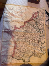
World War II Silk Escape and Evasion Map of France
Antique Prints and Historical Maps
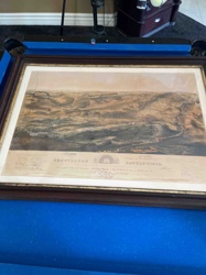
John B. Bachelder's Gettysburg Battle-field Isometrical Drawing

Military Order/Medal
Pour le Mérite (Blue Max) Military Order

Military Order/Decoration
Pour le Mérite (Blue Max) Military Order

Military Order/Medal
Pour le Mérite (Blue Max)
Military Art & Memorabilia
The Missing Man (Vietnam War Memorial Art Exhibit Print)

Military Medal/Order
Pour le Mérite (Blue Max) Medal

Military Order/Medal
Pour le Mérite (Blue Max) Medal

Military Decoration
Pour le Mérite Medal (Blue Max)
Antique Maps and Prints
Queen-Hith Ward and Vintry Ward Map with St. Michael’s Queen-Hith Church
Military Memorabilia / Cartography
World War II Silk Escape and Evasion Map of France
Antique Prints and Historical Maps
John B. Bachelder's Gettysburg Battle-field Isometrical Drawing
Military Order/Medal
Pour le Mérite (Blue Max) Military Order
Military Order/Decoration
Pour le Mérite (Blue Max) Military Order
Military Order/Medal
Pour le Mérite (Blue Max)
Military Art & Memorabilia
The Missing Man (Vietnam War Memorial Art Exhibit Print)
Military Medal/Order
Pour le Mérite (Blue Max) Medal
Military Order/Medal
Pour le Mérite (Blue Max) Medal
Military Decoration
Pour le Mérite Medal (Blue Max)
Process
How our AI farringdon ward map appraisal works
- 01
Upload your photo
Take a clear photo of your farringdon ward map and upload it. One photo is all you need.
- 02
AI analysis
Our advanced AI technology analyzes your item.
- 03
Receive estimate
Get a detailed appraisal report with estimated value range, market insights, and item details.
Get the best appraisal
For the best results
- Use good lighting to capture all details
- Place item on a neutral background
- Include any identifying marks or labels
- Ensure the entire item is visible in frame
Ready to appraise your farringdon ward map?
Get your free AI-powered appraisal in under 60 seconds
No registration required · Free to use · Instant results