AI Item Analysis
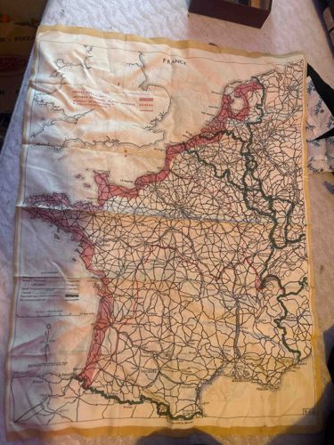
This is a vintage World War II-era military escape and evasion map, specifically Sheet C/D of the French and surrounding European regions. These maps were typically printed on silk or rayon to ensure they were durable, lightweight, waterproof, and silent when unfolded—providing a tactical advantage over paper maps. The item features a multi-color print on a cream-colored textile base with a distinctive golden-yellow border. The map depicts intricate topography, including roads, railways, and international boundaries across France, Belgium, and Holland. Red-shaded zones likely indicate restricted areas or specific frontier zones. The item shows significant signs of age and use, including heavy creasing, some minor fraying along the hemmed edges, and light foxing or staining consistent with long-term storage or field use. The typography is characteristic of 1940s British or American military cartography. These maps were often issued to paratroopers and aircrews to aid in navigation if they were downed behind enemy lines. The printing remained legible, showcasing high-quality craftsmanship for a utilitarian military tool. It represents a significant historical artifact of intelligence and survival equipment from the mid-20th century.