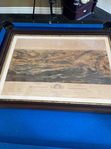
John B. Bachelder's Gettysburg Battle-field Isometrical Drawing
This item is an antique lithographic print titled 'Gettysburg Battle-field,' based on the renowned topographical survey and isometrical drawing by John B. Bachelder. Originally published in 1863 and later updated in various editions, this piece features a high-angle, bird's-eye view detailing the landscape, military movements, and troop placements of the historic American Civil War battle. The print is executed in sepia and earth tones with subtle watercolor tinting. Below the main image, an extensive legend and key include printed facsimiles of signatures from General George G. Meade and other high-ranking officers, vouching for the map's accuracy. Physically, the artwork is housed in a substantial dark wood frame with a gilded inner lip, displaying some minor abrasions and dust accumulation typical of age. The paper shows visible signs of historical wear, specifically concentrated water staining and foxing along the upper left quadrant and bottom margin, along with characteristic yellowing or 'toning' indicative of mid-to-late 19th-century paper stock. The detail in the topography—showing individual farms, fences, and wooded areas—highlights the superior craftsmanship of 19th-century American cartography and commemorative art. Such prints were highly prized by veterans and historians for their documentary precision and aesthetic quality.
AI-Generated Appraisal Disclaimer
Estimated Value
$2,500 - $3,500
Basic Information
Category
Antique Prints and Historical Maps
Appraised On
February 20, 2026
Estimated Value
$2,500 - $3,500
Item Description
This item is an antique lithographic print titled 'Gettysburg Battle-field,' based on the renowned topographical survey and isometrical drawing by John B. Bachelder. Originally published in 1863 and later updated in various editions, this piece features a high-angle, bird's-eye view detailing the landscape, military movements, and troop placements of the historic American Civil War battle. The print is executed in sepia and earth tones with subtle watercolor tinting. Below the main image, an extensive legend and key include printed facsimiles of signatures from General George G. Meade and other high-ranking officers, vouching for the map's accuracy. Physically, the artwork is housed in a substantial dark wood frame with a gilded inner lip, displaying some minor abrasions and dust accumulation typical of age. The paper shows visible signs of historical wear, specifically concentrated water staining and foxing along the upper left quadrant and bottom margin, along with characteristic yellowing or 'toning' indicative of mid-to-late 19th-century paper stock. The detail in the topography—showing individual farms, fences, and wooded areas—highlights the superior craftsmanship of 19th-century American cartography and commemorative art. Such prints were highly prized by veterans and historians for their documentary precision and aesthetic quality.
Related Tags
Explore similar items and categories:
Get Your Items Appraised
Instant estimates of your treasures with AI-powered instant appraisals