Appraisal
Early Map Of India Appraisal
Get AI-powered appraisal estimates for your Early Map Of India. Upload a photo for instant valuation.
Recent early map of india appraisals

Antiquarian Maps and Cartography
Ptolemaic Map of India Intra Gangem (Asia Table X)
Antique Map Reproductions / Cartography
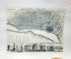
Antiquarian Map of Calcutta and the Hoogly River
Historical Map
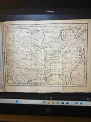
1763 Map of a Portion of North America from Gentlemen's Magazine
Cartographic Illustration / Educational Graphic
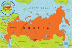
Illustrated Political Map of Russia

Antique Maps and Prints
Framed 18th Century Map of Palestine and Syria

Antique Maps
Historical Map of the United States

Philately
Indian Postage Stamp
Print/Map
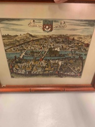
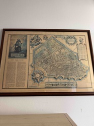
Historic Map/View of Paris (Lutetia) c. 1600
Antiques & Collectibles - Maps and Cartography
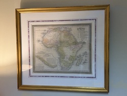
Map of Africa from the Latest Authorities by Thomas, Cowperthwait & Co.

Antique Maps and Prints
Victor Levasseur Map of the Département de Vaucluse
Antiquarian Maps and Cartography
Ptolemaic Map of India Intra Gangem (Asia Table X)
Antique Map Reproductions / Cartography
Antiquarian Map of Calcutta and the Hoogly River
Historical Map
1763 Map of a Portion of North America from Gentlemen's Magazine
Cartographic Illustration / Educational Graphic
Illustrated Political Map of Russia
Antique Maps and Prints
Framed 18th Century Map of Palestine and Syria
Antique Maps
Historical Map of the United States
Philately
Indian Postage Stamp
Print/Map
Historic Map/View of Paris (Lutetia) c. 1600
Antiques & Collectibles - Maps and Cartography
Map of Africa from the Latest Authorities by Thomas, Cowperthwait & Co.
Antique Maps and Prints
Victor Levasseur Map of the Département de Vaucluse
Antiques & Collectibles - Cartography
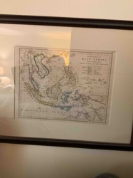
Framed 19th Century Map of the East Indies with the Channels between India, China & New Holland
Philately
Early Indian Postage Stamp

Collectibles/Postal
National Emblem of India Stamp
Cartography & Antiquarian Maps
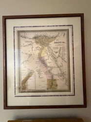
Samuel Augustus Mitchell Antique Framed Map of Egypt
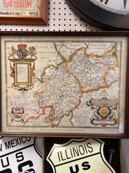
Cartographic Reproductions & Ephemera
Reproduction Saxton's Map of Warwickshire and Leicestershire

Stamps/Philately
100 Paise Stamp
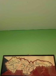
Framed Map / Art
Framed Map of Czechoslovakia (Stylized)

Philately/Collectibles
Indian Postage Stamp
Antique Map
Framed Antique Map of Ferrara (Attributed to Blaeu or similar Dutch Cartographer)

Antique Cartography and Prints
Victor Levasseur 'Atlas National Illustré' Map of the Department of Aude, France
Antiques & Collectibles - Cartography
Framed 19th Century Map of the East Indies with the Channels between India, China & New Holland
Philately
Early Indian Postage Stamp
Collectibles/Postal
National Emblem of India Stamp
Cartography & Antiquarian Maps
Samuel Augustus Mitchell Antique Framed Map of Egypt
Cartographic Reproductions & Ephemera
Reproduction Saxton's Map of Warwickshire and Leicestershire
Stamps/Philately
100 Paise Stamp
Framed Map / Art
Framed Map of Czechoslovakia (Stylized)
Philately/Collectibles
Indian Postage Stamp
Antique Map
Framed Antique Map of Ferrara (Attributed to Blaeu or similar Dutch Cartographer)
Antique Cartography and Prints
Victor Levasseur 'Atlas National Illustré' Map of the Department of Aude, France
Process
How our AI early map of india appraisal works
- 01
Upload your photo
Take a clear photo of your early map of india and upload it. One photo is all you need.
- 02
AI analysis
Our advanced AI technology analyzes your item.
- 03
Receive estimate
Get a detailed appraisal report with estimated value range, market insights, and item details.
Get the best appraisal
For the best results
- Use good lighting to capture all details
- Place item on a neutral background
- Include any identifying marks or labels
- Ensure the entire item is visible in frame
Ready to appraise your early map of india?
Get your free AI-powered appraisal in under 60 seconds
No registration required · Free to use · Instant results