AI Item Analysis
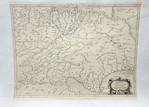
This item is an antique black-and-white woodcut or copperplate engraved map titled 'ASIAE X TAB' centered on India and Southeast Asia. The map is based on Claudius Ptolemy's Geographia and likely dates from the 16th to early 17th century. It features a detailed cartographic representation of 'INDIA INTRA GANGEM' (India within the Ganges), showing rivers, mountain ranges depicted as stylized molehills, and numerous ancient settlements. The geography reflects the transitional Renaissance understanding of the region, where classical Greek knowledge met early Age of Discovery exploration. The margins include a graduated scale for latitude and longitude. A notable decorative feature is the elaborate Baroque-style cartouche in the lower right corner, which contains the latin title text and is flanked by ornamental scrollwork and a cherub face. Physically, the map is printed on aged, off-white laid paper. It shows signs of historic wear, including slight yellowing, foxing, and visible vertical creasing, particularly along the centerfold which suggests it was originally bound in an atlas. Small tears or chips are visible at the upper-right edge. The print quality is high, showing fine linework in the topography and lettering, characteristic of early European printing craftsmanship.