Appraisal
Map Of Central America Or West Indies Appraisal
Get AI-powered appraisal estimates for your Map Of Central America Or West Indies. Upload a photo for instant valuation.
Recent map of central america or west indies appraisals
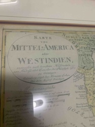
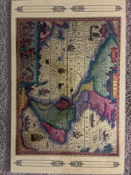
Antique Map
Karte von Mittel-America oder Westindien (Map of Central America or West Indies)
Antiques & Collectibles - Cartography
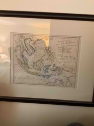
Framed 19th Century Map of the East Indies with the Channels between India, China & New Holland

Antique Cartography and Printed Maps
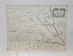
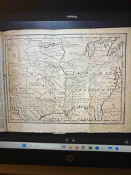
A New & Accurate Map of North America (c. 1790s)
Antique Maps and Cartography
Antique Copperplate Engraved Map of Central Asia - Tabula VII Asiae
Furniture - Seating
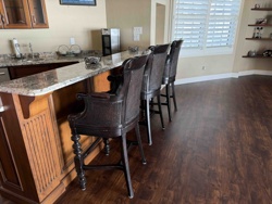
British West Indies Style Counter Height Bar Stools with Cane Backing
Decorative Art / Map Reproduction
Reproduction Antique Map of The Americas
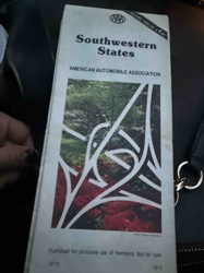
Vintage Map
AAA Southwestern States Road Map
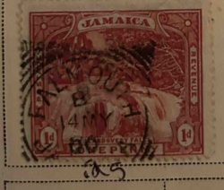
Revenue Stamp
Jamaica 1d Andover Fall Revenue Stamp
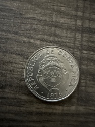
Coins and Numismatics
Costa Rican coinage, as marked 1976
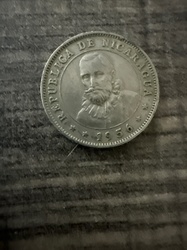
Coins and Numismatics
Coin consistent with a 1956 Nicaraguan 5 Centavos
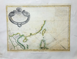
Antique Map
Karte von Mittel-America oder Westindien (Map of Central America or West Indies)
Antiques & Collectibles - Cartography
Framed 19th Century Map of the East Indies with the Channels between India, China & New Holland
Antique Cartography and Printed Maps
A New & Accurate Map of North America (c. 1790s)
Antique Maps and Cartography
Antique Copperplate Engraved Map of Central Asia - Tabula VII Asiae
Furniture - Seating
British West Indies Style Counter Height Bar Stools with Cane Backing
Decorative Art / Map Reproduction
Reproduction Antique Map of The Americas
Vintage Map
AAA Southwestern States Road Map
Revenue Stamp
Jamaica 1d Andover Fall Revenue Stamp
Coins and Numismatics
Costa Rican coinage, as marked 1976
Coins and Numismatics
Coin consistent with a 1956 Nicaraguan 5 Centavos
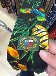
Men's Fashion Accessories / Neckwear
Pusser's of the West Indies Tropical Fish Necktie
Historical Map
1763 Map of a Portion of North America from Gentlemen's Magazine
Art and Collectibles - Cartography / Wall Decor
Framed Reproductions of Visscher and Hondius Maps of America
Antique Maps and Cartography
CARTE HYDRO-GEOGRAPHIQUE DES INDES ORIENTALES by Rigobert Bonne
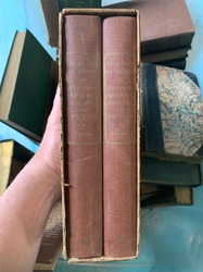
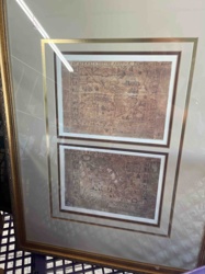
Books and Manuscripts
Two-volume book set of 'Incidents of Travel in Central America, Chiapas, and Yucatan' in slipcase
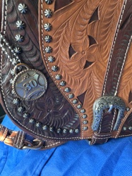
Handbags / Fashion Accessories
American West 30th Anniversary Hand-Tooled Leather Handbag
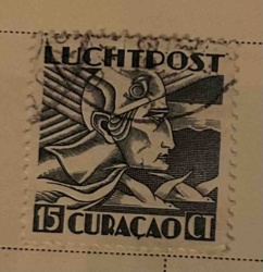
Postage Stamp
Curacao 15 Cent Luftpost Airmail Stamp
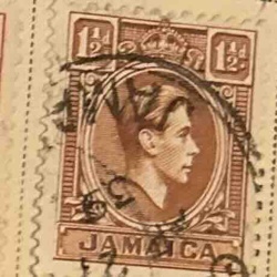
Postage Stamp
Jamaica 1½d Postage Stamp (King George V)
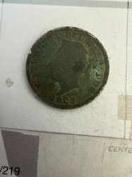
Coins and Numismatics
Circulated coin as marked Republic of El Salvador, dated 1925
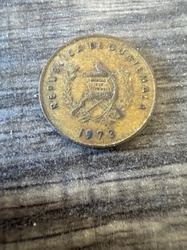
Coins and Numismatics
Coin bearing markings from Republic of Guatemala, dated 1973
Men's Fashion Accessories / Neckwear
Pusser's of the West Indies Tropical Fish Necktie
Historical Map
1763 Map of a Portion of North America from Gentlemen's Magazine
Art and Collectibles - Cartography / Wall Decor
Framed Reproductions of Visscher and Hondius Maps of America
Antique Maps and Cartography
CARTE HYDRO-GEOGRAPHIQUE DES INDES ORIENTALES by Rigobert Bonne
Books and Manuscripts
Two-volume book set of 'Incidents of Travel in Central America, Chiapas, and Yucatan' in slipcase
Handbags / Fashion Accessories
American West 30th Anniversary Hand-Tooled Leather Handbag
Postage Stamp
Curacao 15 Cent Luftpost Airmail Stamp
Postage Stamp
Jamaica 1½d Postage Stamp (King George V)
Coins and Numismatics
Circulated coin as marked Republic of El Salvador, dated 1925
Coins and Numismatics
Coin bearing markings from Republic of Guatemala, dated 1973
Process
How our AI map of central america or west indies appraisal works
- 01
Upload your photo
Take a clear photo of your map of central america or west indies and upload it. One photo is all you need.
- 02
AI analysis
Our advanced AI technology analyzes your item.
- 03
Receive estimate
Get a detailed appraisal report with estimated value range, market insights, and item details.
Get the best appraisal
For the best results
- Use good lighting to capture all details
- Place item on a neutral background
- Include any identifying marks or labels
- Ensure the entire item is visible in frame
Ready to appraise your map of central america or west indies?
Get your free AI-powered appraisal in under 60 seconds
No registration required · Free to use · Instant results