Appraisal
County Map Of Virginia And North Carolina Appraisal
Get AI-powered appraisal estimates for your County Map Of Virginia And North Carolina. Upload a photo for instant valuation.
Recent county map of virginia and north carolina appraisals
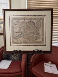
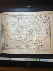
Antique Maps and Cartography
Samuel Augustus Mitchell 'County Map of Virginia and North Carolina' (c. 1860-1867)
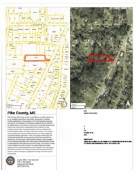
Real Estate Document
Pike County, MS Property Map
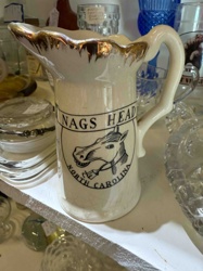
Ceramics
Nags Head North Carolina Souvenir Pitcher

Antique Cartography and Printed Maps
A New & Accurate Map of North America (c. 1790s)
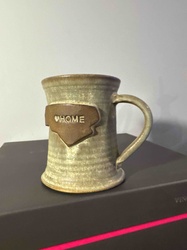
Handmade Pottery / Drinkware
Handcrafted Stoneware North Carolina 'Home' Mug
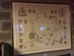
Cartographic Reproductions & Ephemera
Reproduction Saxton's Map of Warwickshire and Leicestershire
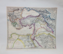
Antique Maps and Cartography
Stieler's Hand-Atlas Map: Das Mittelländische Meer und Nord-Afrika

Sports Memorabilia - Photograph
Black and White Photograph of Michael Jordan at UNC
Wall Art and Maps
Framed Napa Valley 'Vintage Expedition' Illustrative Map

Prints and Maps
Vintage city map of Florence (Firenze), Italy
Antique Maps and Cartography
Samuel Augustus Mitchell 'County Map of Virginia and North Carolina' (c. 1860-1867)
Real Estate Document
Pike County, MS Property Map
Ceramics
Nags Head North Carolina Souvenir Pitcher
Antique Cartography and Printed Maps
A New & Accurate Map of North America (c. 1790s)
Handmade Pottery / Drinkware
Handcrafted Stoneware North Carolina 'Home' Mug
Cartographic Reproductions & Ephemera
Reproduction Saxton's Map of Warwickshire and Leicestershire
Antique Maps and Cartography
Stieler's Hand-Atlas Map: Das Mittelländische Meer und Nord-Afrika
Sports Memorabilia - Photograph
Black and White Photograph of Michael Jordan at UNC
Wall Art and Maps
Framed Napa Valley 'Vintage Expedition' Illustrative Map
Prints and Maps
Vintage city map of Florence (Firenze), Italy
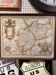
Art & Collectibles
Framed Pictorial Map of County Durham
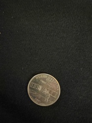
Numismatics / United States Coinage
2001 North Carolina State Quarter
Historical Map
1763 Map of a Portion of North America from Gentlemen's Magazine
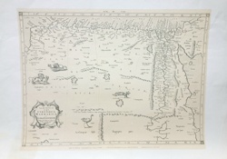
Antique Maps and Prints
Antique Copperplate Engraved Map of North Africa (Cyrenaica, Marmarica, and Libya Exterior)
Antique Maps and Cartography
Ptolemaic Map of North Africa (Tabula Aphricae II)
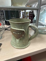
Handmade Ceramics and Pottery
Studio Pottery North Carolina 'Home' Mug
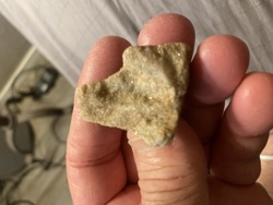
Archeological Artifacts / Native American Lithics
Yadkin Triangular Projectile Point

Collectible Sports Memorabilia
Gamecock Country Poster
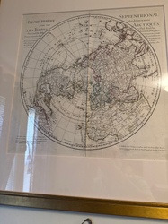
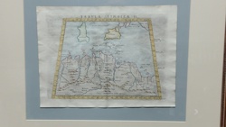
Historical Maps and Prints
Framed circular map of the Northern Hemisphere in the 18th-century French style
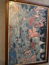
Prints and Maps
Illustrated map titled 'The Land of Make Believe' in a wooden frame
Art & Collectibles
Framed Pictorial Map of County Durham
Numismatics / United States Coinage
2001 North Carolina State Quarter
Historical Map
1763 Map of a Portion of North America from Gentlemen's Magazine
Antique Maps and Prints
Antique Copperplate Engraved Map of North Africa (Cyrenaica, Marmarica, and Libya Exterior)
Antique Maps and Cartography
Ptolemaic Map of North Africa (Tabula Aphricae II)
Handmade Ceramics and Pottery
Studio Pottery North Carolina 'Home' Mug
Archeological Artifacts / Native American Lithics
Yadkin Triangular Projectile Point
Collectible Sports Memorabilia
Gamecock Country Poster
Historical Maps and Prints
Framed circular map of the Northern Hemisphere in the 18th-century French style
Prints and Maps
Illustrated map titled 'The Land of Make Believe' in a wooden frame
Process
How our AI county map of virginia and north carolina appraisal works
- 01
Upload your photo
Take a clear photo of your county map of virginia and north carolina and upload it. One photo is all you need.
- 02
AI analysis
Our advanced AI technology analyzes your item.
- 03
Receive estimate
Get a detailed appraisal report with estimated value range, market insights, and item details.
Get the best appraisal
For the best results
- Use good lighting to capture all details
- Place item on a neutral background
- Include any identifying marks or labels
- Ensure the entire item is visible in frame
Ready to appraise your county map of virginia and north carolina?
Get your free AI-powered appraisal in under 60 seconds
No registration required · Free to use · Instant results