AI Appraisal Estimate

AI-generated estimates · not official valuations

From the user

What was submitted

Photo and notes provided by the user — not generated by AI

Submitted item photo
Submitted photo · June 13, 2026

User's notes

No additional notes provided.

AI analysis below

AI appraisal

AI analysis & estimate

AI-Generated · Verify before acting

Everything below is generated by AI for informational purposes only. AI can make mistakes — the AI may misidentify items or misattribute them (artist, maker, brand, designer, origin, era). This is not an official valuation and should not be used for insurance, sale, tax, estate, legal, or lending purposes — or any decision requiring a certified appraisal. It is not an authoritative claim about any person, brand, or rights holder — do not share or rely on it as a factual statement about a third party. Always consult qualified professionals before making financial decisions.

Read the full disclaimer

AI Identification

·Not independently authenticated·Verify before acting

Stieler's Hand-Atlas Map: Das Mittelländische Meer und Nord-Afrika

Antique Maps and Cartography

AI Estimated Value

·Not an official valuation·Verify before acting

$125 - $175

As of June 13, 2026

AI Item Analysis

·AI can make mistakes·Verify before acting
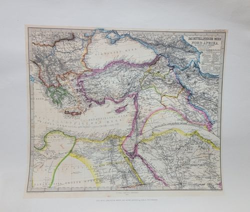
This is a detailed 19th-century steel-engraved map titled 'Das Mittelländische Meer und Nord-Afrika' (The Mediterranean Sea and North Africa), plate number 52 from Stieler's Hand-Atlas. The map is a fine example of German cartography by Justus Perthes of Gotha, likely dating to the 1870s or 1880s based on the topographical style and political boundaries shown. It is printed on heavy cream-toned paper with exquisite hand-colored outlines in pink, yellow, blue, and green to denote regional borders. The map covers a vast area including Southeastern Europe, the Ottoman Empire (Turkey, Levant), and Northern Africa from Egypt to the Maghreb. The level of detail is exceptional, featuring mountainous hachuring, river systems, and densely packed place names in German. Notable markings include the title cartouche in the upper right, a detailed legend, and the 'Stieler's Hand-Atlas' series identifier. The condition appears fair to good with minor edge wear, slight curling of the paper, and typical light age-toning. There are visible creases at the corners and a central fold consistent with atlas binding. The craftsmanship reflects the high standards of the Geographische Anstalt in Gotha, known for precision and scientific accuracy during the Victorian era.

AI Appraisal Report

·AI can make mistakes·Verify before acting
I have conducted a visual examination of the 19th-century steel-engraved map 'Das Mittelländische Meer und Nord-Afrika' from Stieler’s Hand-Atlas. The piece demonstrates the hallmarks of the Justus Perthes Geographische Anstalt, including precise hachuring and the characteristic hand-outlined coloring used to distinguish political boundaries. Authenticity is supported by the visible central fold and plate number 52, consistent with the binding of the 1870s-1880s editions. The condition is fair to good; while the engraving remains sharp, the paper shows expected age-toning, minor corner creasing, and edge wear that suggests it was removed from a well-used atlas. Market conditions for Stieler maps remain stable. While not as rare as early 17th-century cartography, Stieler engravings are highly collected for their scientific accuracy and aesthetic 'Victorian' appeal. Comparables for individual plates of the Mediterranean region generally settle in the $100–$200 range, depending on the vibrancy of the color and the presence of foxing. This specimen’s value is bolstered by the popular geographical focus on the Ottoman Empire and North Africa, though the minor physical wear prevents it from reaching the premium retail tier. Limitations: This appraisal is based on digital imagery. A physical inspection is required to confirm the presence of a watermark, check for paper brittleness (acidification), and ensure the coloring is original pigment rather than modern reproduction. Full authentication would benefit from provenance detailing the specific edition year of the parent atlas. Scientific testing of the ink and paper fibers would be necessary to definitively rule out high-quality 20th-century facsimiles.

Get your items appraised

Instant estimates of your treasures with AI-powered appraisals

Browse More Appraisals