AI Appraisal Estimate

AI-generated estimates · not official valuations

From the user

What was submitted

Photo and notes provided by the user — not generated by AI

Submitted item photo
Submitted photo · June 13, 2026

User's notes

No additional notes provided.

AI analysis below

AI appraisal

AI analysis & estimate

AI-Generated · Verify before acting

Everything below is generated by AI for informational purposes only. AI can make mistakes — the AI may misidentify items or misattribute them (artist, maker, brand, designer, origin, era). This is not an official valuation and should not be used for insurance, sale, tax, estate, legal, or lending purposes — or any decision requiring a certified appraisal. It is not an authoritative claim about any person, brand, or rights holder — do not share or rely on it as a factual statement about a third party. Always consult qualified professionals before making financial decisions.

Read the full disclaimer

AI Identification

·Not independently authenticated·Verify before acting

Antique Copperplate Engraved Map of North Africa (Cyrenaica, Marmarica, and Libya Exterior)

Antique Maps and Prints

AI Estimated Value

·Not an official valuation·Verify before acting

$450 - $650

As of June 13, 2026

AI Item Analysis

·AI can make mistakes·Verify before acting
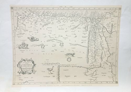
This is a monochrome antique map printed via copperplate engraving on laid paper, depicting the regions of Cyrenaica, Marmarica, and Libya Exterior in North Africa, including the Nile River valley. The map is characterized by its high-quality line work and classical cartographic style, likely dating to the 17th or early 18th century. It features an ornate decorative cartouche in the lower-left corner with scrollwork and figures, typical of the Baroque style. The geography is populated with various illustrations of fauna including lions, an ostrich, and a crocodile, alongside stylized mountain ranges and major river systems. The text is in Latin, utilizing classical nomenclature for geographic features. Physically, the paper shows a slight warm patina consistent with age, with sharp plate marks visible at the margins. The horizontal orientation and the presence of a central vertical fold suggest it may have originally been part of an atlas. The printing is crisp, indicating it was pulled from a plate in relatively good condition. There are minor signs of handling wear at the edges, but no visible significant foxing or tearing. The craftsmanship reflects the precision of European cartographers from the Dutch or French schools of the Golden Age of cartography, prioritizing both geographical information and aesthetic ornamentation.

AI Appraisal Report

·AI can make mistakes·Verify before acting
Upon visual examination of this copperplate engraved map of North Africa, I find it to be a representative example of 17th-century cartography, likely originating from a Dutch or French atlas such as those by Cluverius or his contemporaries. The engraving exhibits the characteristic sharp line work and heavy plate indentation consistent with early modern intaglio printing. The use of laid paper with a visible center fold and a warm patina supports its authenticity as an original period strike rather than a later reproduction. The condition appears remarkably stable. The clarity of the decorative cartouche and the whimsical illustrations of regional fauna—lions, crocodiles, and ostriches—remain crisp, which is a primary driver for collector interest. Market demand for classical North African maps remains steady, particularly for examples that blend geographic curiosity with Baroque aesthetic appeal. Comparable sales for monochrome folio maps of this region typically fall in the mid-hundreds, though professional hand-coloring or a specific attribution to a master like Blaeu or Hondius could elevate this value. Limitations: My assessment is based solely on digital images. Without a physical inspection, I cannot verify the watermark to confirm the paper’s exact mill and date, nor can I check for hidden thinning, expert repairs, or acidic residue from previous framing. To finalize this appraisal, I would recommend an in-person examination under raking light to assess the paper's integrity and a review of provenance documentation to track its history of ownership. Scientific testing of the ink acidity is generally not required for this class of object, but identifying the specific watermark against the Briquet or Churchill catalogs would definitively secure its place in the cartographic timeline.

Get your items appraised

Instant estimates of your treasures with AI-powered appraisals

Browse More Appraisals