Appraisal
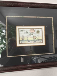
Map Of The Sandwich Isles Appraisal
Get AI-powered appraisal estimates for your Map Of The Sandwich Isles. Upload a photo for instant valuation.
Recent map of the sandwich isles appraisals
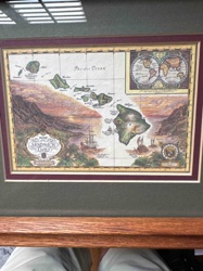
Framed Art/Map
Framed 'Map of The Sandwich Isles' Decorative Print
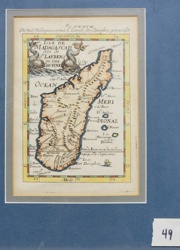
Antique Maps and Prints
Alain Manesson-Mallet - Isle de Madagascar (1683)
Decorative Art / Map Reproduction
Reproduction Antique Map of The Americas

Antique Cartography and Prints
Victor Levasseur 'Atlas National Illustré' Map of the Department of Aude, France

Antique Cartography and Fine Art Prints
Antique Engraved Map of the Province of Essex
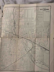
Antique Maps and Cartography
Vintage Map of the City of Jackson, Michigan

Antique Maps and Prints
Victor Levasseur Antique Map of the Tarn-et-Garonne Department
Antique Maps and Prints
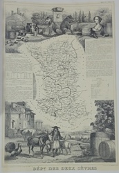
Antiquarian Map of the Département des Deux-Sèvres from Atlas National Illustré
Kitchenware and Tableware
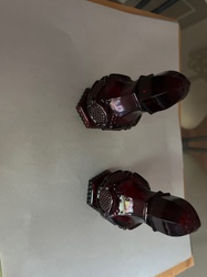
Ruby-colored pressed glass salt and pepper shakers in the style of Tiara Glass sandwich pattern
Antique Books and Ephemera
Antiquarian and Picturesque Guide to the Isle of Wight
Framed Art/Map
Framed 'Map of The Sandwich Isles' Decorative Print
Antique Maps and Prints
Alain Manesson-Mallet - Isle de Madagascar (1683)
Decorative Art / Map Reproduction
Reproduction Antique Map of The Americas
Antique Cartography and Prints
Victor Levasseur 'Atlas National Illustré' Map of the Department of Aude, France
Antique Cartography and Fine Art Prints
Antique Engraved Map of the Province of Essex
Antique Maps and Cartography
Vintage Map of the City of Jackson, Michigan
Antique Maps and Prints
Victor Levasseur Antique Map of the Tarn-et-Garonne Department
Antique Maps and Prints
Antiquarian Map of the Département des Deux-Sèvres from Atlas National Illustré
Kitchenware and Tableware
Ruby-colored pressed glass salt and pepper shakers in the style of Tiara Glass sandwich pattern
Antique Books and Ephemera
Antiquarian and Picturesque Guide to the Isle of Wight
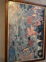
Decorative Wall Art / Cartography
Vintage-Style Map of The Sandwich Isles (Hawaii) Illustration

Antique Maps
Historical Map of the United States

Antique Maps and Prints
Victor Levasseur Map of the Département de Vaucluse
Decorative Art / Collectible Map
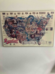
Framed 'Baseball: A Rich Heritage' Illustrated Map of the USA

Antique Maps and Prints
Antique Illustrated Lithograph Map of the Department of Tarn, France
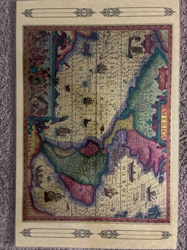
Antiques & Collectibles - Cartography
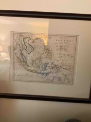
Framed 19th Century Map of the East Indies with the Channels between India, China & New Holland
Wall Decor / Cartography
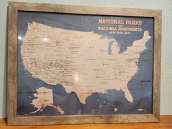
Framed National Parks and National Monuments Map of the United States
Historical Maps and Prints
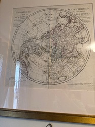
Framed circular map of the Northern Hemisphere in the 18th-century French style
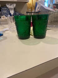
Glassware
Pressed glass tumblers in the style of Tiara sandwich glass
Prints and Maps
Illustrated map titled 'The Land of Make Believe' in a wooden frame
Decorative Wall Art / Cartography
Vintage-Style Map of The Sandwich Isles (Hawaii) Illustration
Antique Maps
Historical Map of the United States
Antique Maps and Prints
Victor Levasseur Map of the Département de Vaucluse
Decorative Art / Collectible Map
Framed 'Baseball: A Rich Heritage' Illustrated Map of the USA
Antique Maps and Prints
Antique Illustrated Lithograph Map of the Department of Tarn, France
Antiques & Collectibles - Cartography
Framed 19th Century Map of the East Indies with the Channels between India, China & New Holland
Wall Decor / Cartography
Framed National Parks and National Monuments Map of the United States
Historical Maps and Prints
Framed circular map of the Northern Hemisphere in the 18th-century French style
Glassware
Pressed glass tumblers in the style of Tiara sandwich glass
Prints and Maps
Illustrated map titled 'The Land of Make Believe' in a wooden frame
Process
How our AI map of the sandwich isles appraisal works
- 01
Upload your photo
Take a clear photo of your map of the sandwich isles and upload it. One photo is all you need.
- 02
AI analysis
Our advanced AI technology analyzes your item.
- 03
Receive estimate
Get a detailed appraisal report with estimated value range, market insights, and item details.
Get the best appraisal
For the best results
- Use good lighting to capture all details
- Place item on a neutral background
- Include any identifying marks or labels
- Ensure the entire item is visible in frame
Ready to appraise your map of the sandwich isles?
Get your free AI-powered appraisal in under 60 seconds
No registration required · Free to use · Instant results